IMAGES TAKEN NEAR TO
Cavendish Drive, NORTHAMPTON, NN3 3DH
Introduction
This page details the photographs taken nearby to Cavendish Drive, NN3 3DH by members of the Geograph project.
The Geograph project started in 2005 with the aim of publishing, organising and preserving representative images for every square kilometre of Great Britain, Ireland and the Isle of Man.

There are currently over 7.5m images from over14,400 individuals and you can help contribute to the project by visiting https://www.geograph.org.uk
Image Map
Images are licensed for reuse under creativecommons.org/licenses/by-sa/2.0
Notes
- Clicking on the map will re-center to the selected point.
- The higher the marker number, the further away the image location is from the centre of the postcode.
Image Listing (21 Images Found)
Images are licensed for reuse under creativecommons.org/licenses/by-sa/2.0
Image
Details
Distance
1
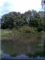
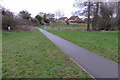
Abington Vale
A pond in the suburbs of Northampton.
Image: © Burgess Von Thunen
Taken: 25 May 2011
0.05 miles
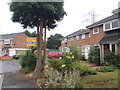
4

Bowthorpe Close
1980s houses in Langlands.
Image: © Burgess Von Thunen
Taken: 23 Oct 2015
0.08 miles
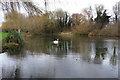
5
Billing Road East
At the roundabout with Cavendish Drive.
Image: © Burgess Von Thunen
Taken: 25 May 2011
0.09 miles
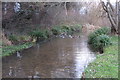
7
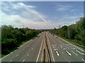
Nene Valley Way
A45 looking west.
Image: © Burgess Von Thunen
Taken: 25 May 2011
0.12 miles
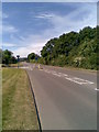
8
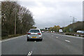
A45 Nene Valley Way
Towards the M1. The three lanes reduce to two at the next junction.
Image: © Robin Webster
Taken: 5 Dec 2021
0.13 miles
9
Annesley Close
1970s houses in Langlands.
Image: © Burgess Von Thunen
Taken: 13 Jul 2015
0.13 miles
10
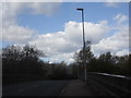
Northampton: Weston Mill Lane
Looking Northwest of Weston Mill Lane of the town. The bridge crossing the A45 Nene Valley Way.
Image: © Jareth W
Taken: 11 Apr 2015
0.14 miles