IMAGES TAKEN NEAR TO
Ridgeway, NORTHAMPTON, NN3 3AN
Introduction
This page details the photographs taken nearby to Ridgeway, NN3 3AN by members of the Geograph project.
The Geograph project started in 2005 with the aim of publishing, organising and preserving representative images for every square kilometre of Great Britain, Ireland and the Isle of Man.

There are currently over 7.5m images from over14,400 individuals and you can help contribute to the project by visiting https://www.geograph.org.uk
Image Map
Images are licensed for reuse under creativecommons.org/licenses/by-sa/2.0
Notes
- Clicking on the map will re-center to the selected point.
- The higher the marker number, the further away the image location is from the centre of the postcode.
Image Listing (32 Images Found)
Images are licensed for reuse under creativecommons.org/licenses/by-sa/2.0
Image
Details
Distance
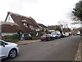
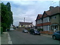
1
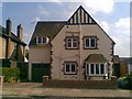
Ridgeway
1920s house in Weston Favell.
Image: © Burgess Von Thunen
Taken: 4 Jun 2010
0.02 miles
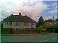
2
Hillside Way
1960s house in Weston Favell.
Image: © Burgess Von Thunen
Taken: 24 Jun 2010
0.04 miles
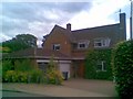
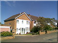
3
Ridgeway
1950s semis in Weston Favell.
Image: © Burgess Von Thunen
Taken: 17 Jun 2010
0.05 miles
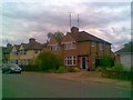
4
Corner of Weston Way and Ridgeway
This house has just had the thatch replaced and the thatcher's truck is still outside.
Image: © Burgess Von Thunen
Taken: 26 Apr 2010
0.06 miles
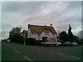
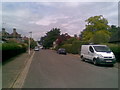
5
Weston Way
Thatched houses in Weston Favell.
Image: © Burgess Von Thunen
Taken: 30 Mar 2016
0.06 miles
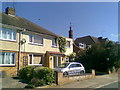
6
Weston Way
1950s semis in Weston Favell.
Image: © Burgess Von Thunen
Taken: 24 Jun 2010
0.09 miles
7
Ridgeway
1930s semis in Weston Favell.
Image: © Burgess Von Thunen
Taken: 24 Jun 2010
0.10 miles
8
Hillside Way
1960s detached houses in Weston Favell.
Image: © Burgess Von Thunen
Taken: 17 Jun 2010
0.10 miles
9
Holmfield Way
1950s semis in Weston Favell.
Image: © Burgess Von Thunen
Taken: 24 Jun 2010
0.10 miles
10
Greenway
Looking towards Wellingborough Road.
Image: © Burgess Von Thunen
Taken: 24 Jun 2010
0.12 miles