IMAGES TAKEN NEAR TO
Briton Gardens, NORTHAMPTON, NN3 2BT
Introduction
This page details the photographs taken nearby to Briton Gardens, NN3 2BT by members of the Geograph project.
The Geograph project started in 2005 with the aim of publishing, organising and preserving representative images for every square kilometre of Great Britain, Ireland and the Isle of Man.

There are currently over 7.5m images from over14,400 individuals and you can help contribute to the project by visiting https://www.geograph.org.uk
Image Map
Images are licensed for reuse under creativecommons.org/licenses/by-sa/2.0
Notes
- Clicking on the map will re-center to the selected point.
- The higher the marker number, the further away the image location is from the centre of the postcode.
Image Listing (85 Images Found)
Images are licensed for reuse under creativecommons.org/licenses/by-sa/2.0
Image
Details
Distance
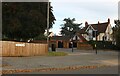
1
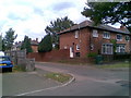
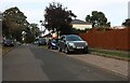
Briton Road
1930s council houses at the junction of Briton Gardens in Abington.
Image: © Burgess Von Thunen
Taken: 13 Jul 2011
0.04 miles
2
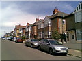
Beech Avenue
1930s houses in Abington.
Image: © Burgess Von Thunen
Taken: 25 May 2011
0.05 miles
3
Abington Community Centre
On Wheatfield Road South.
Image: © Burgess Von Thunen
Taken: 13 Jul 2011
0.05 miles
4
Briton Road
1930s council houses in Abington.
Image: © Burgess Von Thunen
Taken: 4 May 2010
0.06 miles
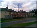
6
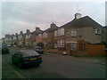
Beech Avenue
1930s suburban semi's in Abington.
Image: © Burgess Von Thunen
Taken: 24 Mar 2010
0.06 miles
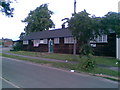
7
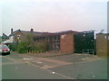
Wheatfield Road South
Apparently disused commercial building in Abington.
Image: © Burgess Von Thunen
Taken: 4 Jul 2011
0.07 miles
8
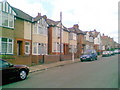
Beech Avenue
1920s semis in Abington.
Image: © Burgess Von Thunen
Taken: 2 Jul 2011
0.07 miles
9
Briton Road at the junction of Wellingborough Road
Image: © David Howard
Taken: 9 Oct 2022
0.08 miles
10
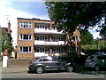
Wellingborough Road
Flats overlooking Abington Park.
Image: © Burgess Von Thunen
Taken: 25 May 2011
0.08 miles