IMAGES TAKEN NEAR TO
Poplar Place, WELLINGBOROUGH, NN29 7SD
Introduction
This page details the photographs taken nearby to Poplar Place, NN29 7SD by members of the Geograph project.
The Geograph project started in 2005 with the aim of publishing, organising and preserving representative images for every square kilometre of Great Britain, Ireland and the Isle of Man.

There are currently over 7.5m images from over14,400 individuals and you can help contribute to the project by visiting https://www.geograph.org.uk
Image Map
Images are licensed for reuse under creativecommons.org/licenses/by-sa/2.0
Notes
- Clicking on the map will re-center to the selected point.
- The higher the marker number, the further away the image location is from the centre of the postcode.
Image Listing (6 Images Found)
Images are licensed for reuse under creativecommons.org/licenses/by-sa/2.0
Image
Details
Distance
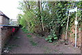
1

Industrial Estate
Looking south. The public footpath from Bozeat goes past these warehouses.
Image: © Will Lovell
Taken: 22 Mar 2006
0.17 miles
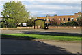
3
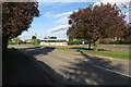
Trees on the Irchester Road
In front of Wollaston School
Image: © Philip Jeffrey
Taken: 22 Apr 2018
0.23 miles
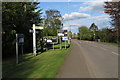
5

Derelict Factory
In The Gap, formerly Park Street, Wollaston.
Image: © Will Lovell
Taken: 17 Apr 2007
0.24 miles