IMAGES TAKEN NEAR TO
London Road, WELLINGBOROUGH, NN29 7QP
Introduction
This page details the photographs taken nearby to London Road, NN29 7QP by members of the Geograph project.
The Geograph project started in 2005 with the aim of publishing, organising and preserving representative images for every square kilometre of Great Britain, Ireland and the Isle of Man.

There are currently over 7.5m images from over14,400 individuals and you can help contribute to the project by visiting https://www.geograph.org.uk
Image Map
Images are licensed for reuse under creativecommons.org/licenses/by-sa/2.0
Notes
- Clicking on the map will re-center to the selected point.
- The higher the marker number, the further away the image location is from the centre of the postcode.
Image Listing (9 Images Found)
Images are licensed for reuse under creativecommons.org/licenses/by-sa/2.0
Image
Details
Distance
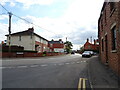
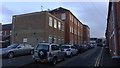
1
An old works or small factory
Located at the junction of London Road and Rotten Row. The dumper truck suggests changes are imminent.
Image: © Michael Trolove
Taken: 7 Oct 2012
0.06 miles
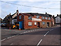
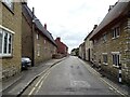
2
Walkers Shoe Factory
Converted flats in Wollaston.
Image: © Burgess Von Thunen
Taken: 21 Nov 2018
0.09 miles
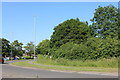
3
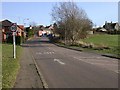
Outskirts of Wollaston
Taken from a road off the A509 and to the south of Hardwater Road.
Image: © Kokai
Taken: 1 Mar 2006
0.11 miles
5
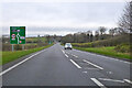
A509 towards Wellingborough
Bypassing Wollaston, which is to the right.
Image: © Robin Webster
Taken: 5 Dec 2021
0.20 miles
7
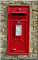
George V postbox on High Street
Postbox No. NN29 78.
Image: © JThomas
Taken: 21 Sep 2022
0.22 miles