IMAGES TAKEN NEAR TO
Cobbs Lane, WELLINGBOROUGH, NN29 7PL
Introduction
This page details the photographs taken nearby to Cobbs Lane, NN29 7PL by members of the Geograph project.
The Geograph project started in 2005 with the aim of publishing, organising and preserving representative images for every square kilometre of Great Britain, Ireland and the Isle of Man.

There are currently over 7.5m images from over14,400 individuals and you can help contribute to the project by visiting https://www.geograph.org.uk
Image Map
Images are licensed for reuse under creativecommons.org/licenses/by-sa/2.0
Notes
- Clicking on the map will re-center to the selected point.
- The higher the marker number, the further away the image location is from the centre of the postcode.
Image Listing (18 Images Found)
Images are licensed for reuse under creativecommons.org/licenses/by-sa/2.0
Image
Details
Distance
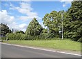
1
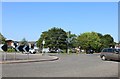
Roundabout on the A509, Wollaston
Part of my large roundabout collection, this was the last visit. https://www.geograph.org.uk/photo/5426114
Image: © David Howard
Taken: 29 Jun 2019
0.10 miles
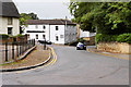
3
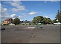
Roundabout on the A509, Wollaston
This is one of the rare current roundabouts without greenery on it.
Image: © David Howard
Taken: 11 Jun 2017
0.11 miles
7
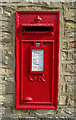
George V postbox on High Street
Postbox No. NN29 78.
Image: © JThomas
Taken: 21 Sep 2022
0.19 miles
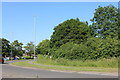
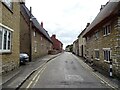
10
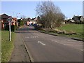
Outskirts of Wollaston
Taken from a road off the A509 and to the south of Hardwater Road.
Image: © Kokai
Taken: 1 Mar 2006
0.21 miles