IMAGES TAKEN NEAR TO
Allens Hill, WELLINGBOROUGH, NN29 7LW
Introduction
This page details the photographs taken nearby to Allens Hill, NN29 7LW by members of the Geograph project.
The Geograph project started in 2005 with the aim of publishing, organising and preserving representative images for every square kilometre of Great Britain, Ireland and the Isle of Man.

There are currently over 7.5m images from over14,400 individuals and you can help contribute to the project by visiting https://www.geograph.org.uk
Image Map
Images are licensed for reuse under creativecommons.org/licenses/by-sa/2.0
Notes
- Clicking on the map will re-center to the selected point.
- The higher the marker number, the further away the image location is from the centre of the postcode.
Image Listing (18 Images Found)
Images are licensed for reuse under creativecommons.org/licenses/by-sa/2.0
Image
Details
Distance
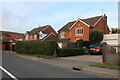
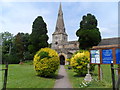
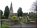
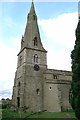
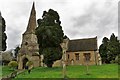
3
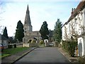
The Church of St Mary, Bozeat
Looking along Church Walk.
Image: © Will Lovell
Taken: 22 Mar 2006
0.09 miles
7
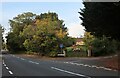
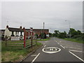
London Road, Bozeat
At the junction of Hensmans Lane.
Image: © David Howard
Taken: 9 Oct 2022
0.14 miles
8
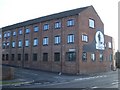
Former Drage Shoe Factory at Bozeat
John Drage & Son, boot & shoe manufacturer, was established in 1861 and their factory shown here at Hope Street in Bozeat was built and extended in the early 20th century. The factory closed to shoe making in 1978. The Drage 'Honest John' logo, shaped like a huge boot, first appeared on the end wall in 1932 and was re-painted in 2000.
Image: © Nigel Stickells
Taken: 14 Jan 2007
0.15 miles
10
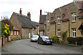
Mile Street, Bozeat
The thatched house is a grade II listed building. The Great Fire of Bozeat destroyed the majority of the village in 1729, this was built 1731.
Image: © Robin Webster
Taken: 4 Sep 2016
0.16 miles