IMAGES TAKEN NEAR TO
Wollaston Road, WELLINGBOROUGH, NN29 7JE
Introduction
This page details the photographs taken nearby to Wollaston Road, NN29 7JE by members of the Geograph project.
The Geograph project started in 2005 with the aim of publishing, organising and preserving representative images for every square kilometre of Great Britain, Ireland and the Isle of Man.

There are currently over 7.5m images from over14,400 individuals and you can help contribute to the project by visiting https://www.geograph.org.uk
Image Map
Images are licensed for reuse under creativecommons.org/licenses/by-sa/2.0
Notes
- Clicking on the map will re-center to the selected point.
- The higher the marker number, the further away the image location is from the centre of the postcode.
Image Listing (10 Images Found)
Images are licensed for reuse under creativecommons.org/licenses/by-sa/2.0
Image
Details
Distance
1
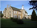
Hinwick Hall
Hinwick Hall dates from the 16th century but was extensively remodelled in the 18th century when the east front was built, as appears above. Further changes were made in the 19th & 20th centuries. The house is Grade II* listed and is now put to excellent use as a further education college for young handicapped people.
Image: © Nigel Stickells
Taken: 14 Jan 2007
0.03 miles
2
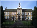
Wrought Iron Entrance Gates at Hinwick Hall
Looking towards the front, eastern elevation, of Hinwick Hall, these wrought iron garden gates, pilasters and side screens with attractive scrollwork are 18th century and Grade II* listed.
Image: © Nigel Stickells
Taken: 14 Jan 2007
0.03 miles
3
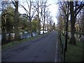
Ornamental Canals & Entrance to Hinwick Hall
The ornamental canals on either side of the entranceway to Hinwick Hall form an attractive feature leading to the Hall itself. The right-hand canal possesses a boat house closeby to the entrance.
Image: © Nigel Stickells
Taken: 14 Jan 2007
0.06 miles
4
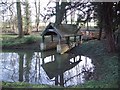
Boathouse at Hinwick Hall
This attractive feature is to be found near to the entrance of the Hall beside the right-hand ornamental canal.
Image: © Nigel Stickells
Taken: 14 Jan 2007
0.06 miles
8

Hinwick House, Near Podington, Bedfordshire
The House, not to be confused with the Hall, dates from the 18th Century. It is built with the typical golden sandstone of the region. It is now in the process of restoration.
Image: © nick macneill
Taken: Unknown
0.23 miles
10
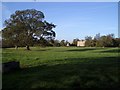
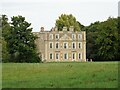
Hinwick House and Parkland
This view of Hinwick House shows the south front viewed across its parkland from the hamlet of Hinwick. The House is Grade I listed and was built 1708-1714, with later additions, for Richard Orlebar.
Image: © Nigel Stickells
Taken: 9 Nov 2006
0.24 miles