IMAGES TAKEN NEAR TO
Arndale, NORTHAMPTON, NN2 8US
Introduction
This page details the photographs taken nearby to Arndale, NN2 8US by members of the Geograph project.
The Geograph project started in 2005 with the aim of publishing, organising and preserving representative images for every square kilometre of Great Britain, Ireland and the Isle of Man.

There are currently over 7.5m images from over14,400 individuals and you can help contribute to the project by visiting https://www.geograph.org.uk
Image Map
Images are licensed for reuse under creativecommons.org/licenses/by-sa/2.0
Notes
- Clicking on the map will re-center to the selected point.
- The higher the marker number, the further away the image location is from the centre of the postcode.
Image Listing (19 Images Found)
Images are licensed for reuse under creativecommons.org/licenses/by-sa/2.0
Image
Details
Distance
1
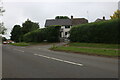
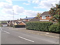
Coverdale
1980s houses in Brampton Park.
Image: © Burgess Von Thunen
Taken: 4 Aug 2011
0.04 miles
2
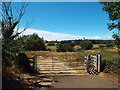
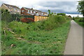
Gate and track near Northampton
A gate and track leading to a weir on the Brampton arm of the River Nene, near Northampton.
Image: © Malc McDonald
Taken: 28 Jul 2018
0.04 miles
3
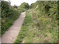
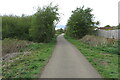
Cycleway 6
Part of the National Cycle Network.
Image: © Kokai
Taken: 15 Aug 2006
0.07 miles
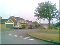
4
Fylingdale
1980s houses in Brampton Park.
Image: © Burgess Von Thunen
Taken: 25 Sep 2015
0.08 miles
5
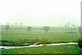
Side weir on Brampton Nene, 1974
There is now a weir across the full stream just right of the masonry visible here. Viewed from a 'Merrymaker' mystery excursion train heading deviously for Norwich. It is here taking the normally freight-only route from Northampton to Market Harborough. This route is now taken up. In the misty distance is a freight train on the main line.
Image: © Robin Webster
Taken: Unknown
0.08 miles
8
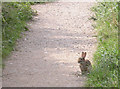
Rabbit on Cycleway
Frozen in a fairly nonchalant manner.
Image: © Kokai
Taken: 15 Aug 2006
0.11 miles
9
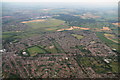
Kingsthorpe to Harlestone Firs: aerial 2014
Looking across Whitehills, with Lodge Farm Industrial Estate left of the Firs and Brampton Golf Course to the right.
Image: © Chris
Taken: 2 Jul 2014
0.12 miles