IMAGES TAKEN NEAR TO
Moulton Lane, NORTHAMPTON, NN2 8RE
Introduction
This page details the photographs taken nearby to Moulton Lane, NN2 8RE by members of the Geograph project.
The Geograph project started in 2005 with the aim of publishing, organising and preserving representative images for every square kilometre of Great Britain, Ireland and the Isle of Man.

There are currently over 7.5m images from over14,400 individuals and you can help contribute to the project by visiting https://www.geograph.org.uk
Image Map
Images are licensed for reuse under creativecommons.org/licenses/by-sa/2.0
Notes
- Clicking on the map will re-center to the selected point.
- The higher the marker number, the further away the image location is from the centre of the postcode.
Image Listing (9 Images Found)
Images are licensed for reuse under creativecommons.org/licenses/by-sa/2.0
Image
Details
Distance
1
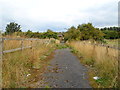
Moulton Lane
Apparently derelict property on the edge of Boughton.
Image: © Burgess Von Thunen
Taken: 11 Sep 2013
0.03 miles
2
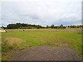
Farmland near Boughton
Paddocks.
Image: © Burgess Von Thunen
Taken: 11 Sep 2013
0.09 miles
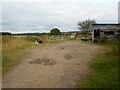
6
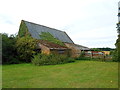
Church Furlong Farm
Farm buildings.
Image: © Burgess Von Thunen
Taken: 11 Sep 2013
0.17 miles
7
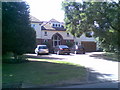
Moulton Lane
A large twentieth century house in Boughton.
Image: © Burgess Von Thunen
Taken: 11 Aug 2010
0.20 miles
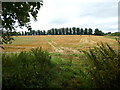
8
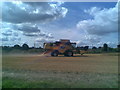
Boughton Green
A combine harvester near Boughton.
Image: © Burgess Von Thunen
Taken: 11 Aug 2010
0.24 miles
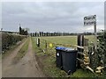
9
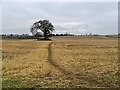
Public footpath to Boughton Green
From Moulton Road.
Image: © Burgess Von Thunen
Taken: 11 Sep 2013
0.24 miles