IMAGES TAKEN NEAR TO
Acre Lane, NORTHAMPTON, NN2 8BE
Introduction
This page details the photographs taken nearby to Acre Lane, NN2 8BE by members of the Geograph project.
The Geograph project started in 2005 with the aim of publishing, organising and preserving representative images for every square kilometre of Great Britain, Ireland and the Isle of Man.

There are currently over 7.5m images from over14,400 individuals and you can help contribute to the project by visiting https://www.geograph.org.uk
Image Map
Images are licensed for reuse under creativecommons.org/licenses/by-sa/2.0
Notes
- Clicking on the map will re-center to the selected point.
- The higher the marker number, the further away the image location is from the centre of the postcode.
Image Listing (10 Images Found)
Images are licensed for reuse under creativecommons.org/licenses/by-sa/2.0
Image
Details
Distance
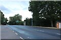
1
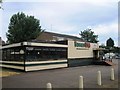
Buddies USA
Former pub The North Star
Image: © Alex McGregor
Taken: 24 Jul 2013
0.13 miles
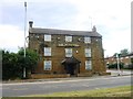
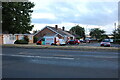
2
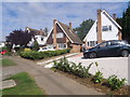
Acre Lane
1970s houses in Spring Park.
Image: © Burgess Von Thunen
Taken: 18 Sep 2015
0.16 miles
3
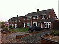
Welford Road
1950s semis in Kingsthorpe.
Image: © Burgess Von Thunen
Taken: 5 Nov 2015
0.17 miles
4
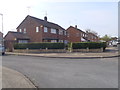
Northfield Way
1960s houses in Kingsthorpe.
Image: © Burgess Von Thunen
Taken: 16 Apr 2015
0.22 miles
7
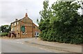
The Windmill pub on Welford Road, Kingsthorpe
Image: © David Howard
Taken: 2 Aug 2022
0.24 miles
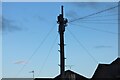
8
Traditional telegraph pole on Welford Road, Kingsthorpe
There aren't many left either with bars across or ceramic insulators.
Image: © David Howard
Taken: 2 Aug 2022
0.24 miles
9
Traditional telegraph pole on Welford Road, Kingsthorpe
Image: © David Howard
Taken: 2 Aug 2022
0.25 miles
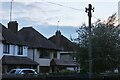
10
Welford Road, Kingsthorpe
Looking towards Larwood Close
Image: © David Howard
Taken: 2 Aug 2022
0.25 miles