IMAGES TAKEN NEAR TO
Newnham Road, NORTHAMPTON, NN2 7QT
Introduction
This page details the photographs taken nearby to Newnham Road, NN2 7QT by members of the Geograph project.
The Geograph project started in 2005 with the aim of publishing, organising and preserving representative images for every square kilometre of Great Britain, Ireland and the Isle of Man.

There are currently over 7.5m images from over14,400 individuals and you can help contribute to the project by visiting https://www.geograph.org.uk
Image Map
Images are licensed for reuse under creativecommons.org/licenses/by-sa/2.0
Notes
- Clicking on the map will re-center to the selected point.
- The higher the marker number, the further away the image location is from the centre of the postcode.
Image Listing (9 Images Found)
Images are licensed for reuse under creativecommons.org/licenses/by-sa/2.0
Image
Details
Distance
1
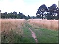
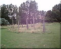
Bradlaugh Fields
A park developed from a former golf course.
Image: © Burgess Von Thunen
Taken: 11 Aug 2013
0.04 miles
2
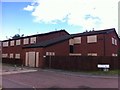
Drayton Walk
Boarded-up council property in St Davids.
Image: © Burgess Von Thunen
Taken: 11 Aug 2013
0.08 miles
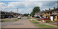
3
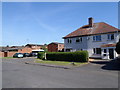
Holdenby Road
1950s council houses in St Davids.
Image: © Burgess Von Thunen
Taken: 11 Jun 2015
0.12 miles
4
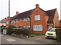
Eastern Avenue North
1930s houses in St Davids.
Image: © Burgess Von Thunen
Taken: 23 Oct 2015
0.18 miles
6
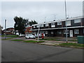
Fulford Drive
1970s shops converted into flats in Links View.
Image: © Burgess Von Thunen
Taken: 30 Aug 2017
0.20 miles
8
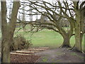
Bradlaugh Fields
Used to be a golf course.
Image: © Burgess Von Thunen
Taken: 5 Apr 2012
0.21 miles
9
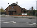
St David's
St David's church stands on Eastern Avenue South in the Northampton suburb of Kingsthorpe.
Image: © Michael Patterson
Taken: 15 Dec 2006
0.21 miles