IMAGES TAKEN NEAR TO
Tollgate Close, NORTHAMPTON, NN2 6RP
Introduction
This page details the photographs taken nearby to Tollgate Close, NN2 6RP by members of the Geograph project.
The Geograph project started in 2005 with the aim of publishing, organising and preserving representative images for every square kilometre of Great Britain, Ireland and the Isle of Man.

There are currently over 7.5m images from over14,400 individuals and you can help contribute to the project by visiting https://www.geograph.org.uk
Image Map
Images are licensed for reuse under creativecommons.org/licenses/by-sa/2.0
Notes
- Clicking on the map will re-center to the selected point.
- The higher the marker number, the further away the image location is from the centre of the postcode.
Image Listing (28 Images Found)
Images are licensed for reuse under creativecommons.org/licenses/by-sa/2.0
Image
Details
Distance
1
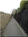
Kingsthorpe
A jetty leading from Green End to Mill Lane.
Image: © Burgess Von Thunen
Taken: 31 Mar 2012
0.06 miles
2
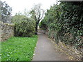
Kingsthorpe
A jetty leading from Green End to Mill Lane.
Image: © Burgess Von Thunen
Taken: 31 Mar 2012
0.07 miles
3
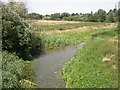
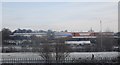
Kingsthorpe Nature Reserve
The small river is the northern branch of the Nene which joins the main river near the brewery in Northampton.
Image: © Kokai
Taken: 19 Jul 2006
0.14 miles
4
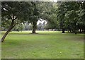
Thornton Park
The park is known locally by the name Thornton although it is shown on some maps as Kingsthorpe Park. The village of Kingsthorpe, now subsumed by Northampton, is a little to the north. Thornton Park provides a convenient route for pedestrians who wish to avoid a busy intersection.
Image: © Kokai
Taken: 15 Aug 2006
0.14 miles
5
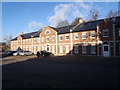
Thornton Hall Close
2000s flats in Kingsthorpe.
Image: © Burgess Von Thunen
Taken: 25 Nov 2015
0.15 miles
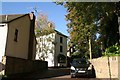
6
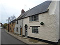
Green End
Cottages in Kingsthorpe.
Image: © Burgess Von Thunen
Taken: 6 Nov 2014
0.16 miles
8
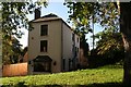
Site of former Church View Stables, Kingsthorpe (2)
See also Image
In the 1960's I rode ponies at Mr. Burgess's stables, and he lived in the house in the centre of the shot. His mobile grocery van was parked in the drive, and Spot the dog guarded his store room opposite the pony stables. There was a small paddock at the back, and a big and productive pear tree on the back wall of the stables. The ponies included Wendy, David, Joey and, later, Penny. In the week they lived usually in a field off Julian way and we collected them and rode them bareback to the stables on Saturday morning. They often galloped the last section, sometimes on the grass of the green (there was no hedge).
Higher up High Street was Mrs. Coates' (Cotes's?) rival stables, now a small housing development.
Image: © Chris
Taken: 27 Oct 2019
0.20 miles
9
Site of former Church View Stables, Kingsthorpe (1)
In the 1960's I rode ponies at Mr. Burgess's stables, and he lived in the house in the centre of the shot. His mobile grocery van was parked in the drive, and Spot the dog guarded his store room opposite the pony stables. There was a small paddock at the back, and a big and productive pear tree on the back wall of the stables. The ponies included Wendy, David, Joey and, later, Penny. In the week they lived usually in a field off Julian way and we collected them and rode them bareback to the stables on Saturday morning. They often galloped the last section, sometimes on the grass of the green (there was no hedge).
Higher up High Street was Mrs. Coates' (Cotes's?) rival stables, now a small housing development.
See also Image
Image: © Chris
Taken: 27 Oct 2019
0.20 miles
10
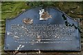
King's Well (the Long Well), in Kingsthorpe (2)
Detail of Image
When I rode ponies in Kingsthorpe in the 1960's there were no bollards in front of this, and on Sundays people drove their cars onto the cobbles and spent a happy morning washing them.
See also Image
Image: © Chris
Taken: 27 Oct 2019
0.20 miles