IMAGES TAKEN NEAR TO
Bembridge Drive, NORTHAMPTON, NN2 6LZ
Introduction
This page details the photographs taken nearby to Bembridge Drive, NN2 6LZ by members of the Geograph project.
The Geograph project started in 2005 with the aim of publishing, organising and preserving representative images for every square kilometre of Great Britain, Ireland and the Isle of Man.

There are currently over 7.5m images from over14,400 individuals and you can help contribute to the project by visiting https://www.geograph.org.uk
Image Map
Images are licensed for reuse under creativecommons.org/licenses/by-sa/2.0
Notes
- Clicking on the map will re-center to the selected point.
- The higher the marker number, the further away the image location is from the centre of the postcode.
Image Listing (15 Images Found)
Images are licensed for reuse under creativecommons.org/licenses/by-sa/2.0
Image
Details
Distance
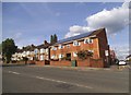
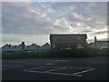
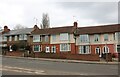
1
Bembridge Drive
1930s houses in Queens Park.
Image: © Burgess Von Thunen
Taken: 10 Jun 2011
0.02 miles
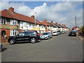
2
Thornton Road
1930s houses in Northampton.
Image: © Burgess Von Thunen
Taken: 11 Mar 2014
0.07 miles
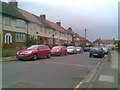
5
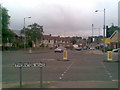
Thornton Road
At the junction with Harborough Road.
Image: © Burgess Von Thunen
Taken: 10 Jun 2011
0.15 miles
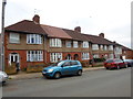
6
Lyncroft Way
1930s houses in Kingsthorpe Hollow.
Image: © Burgess Von Thunen
Taken: 22 Apr 2014
0.15 miles
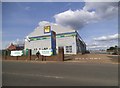
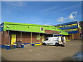
8

Ready Steady Store on Kingsthorpe Road, Northampton
Image: © David Howard
Taken: 2 Aug 2022
0.16 miles