IMAGES TAKEN NEAR TO
St. Andrews Road, NORTHAMPTON, NN2 6BN
Introduction
This page details the photographs taken nearby to St. Andrews Road, NN2 6BN by members of the Geograph project.
The Geograph project started in 2005 with the aim of publishing, organising and preserving representative images for every square kilometre of Great Britain, Ireland and the Isle of Man.

There are currently over 7.5m images from over14,400 individuals and you can help contribute to the project by visiting https://www.geograph.org.uk
Image Map
Images are licensed for reuse under creativecommons.org/licenses/by-sa/2.0
Notes
- Clicking on the map will re-center to the selected point.
- The higher the marker number, the further away the image location is from the centre of the postcode.
Image Listing (13 Images Found)
Images are licensed for reuse under creativecommons.org/licenses/by-sa/2.0
Image
Details
Distance
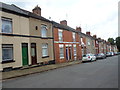
1
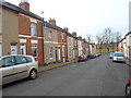
Brook Street
Victorian terraces in Semilong.
Image: © Burgess Von Thunen
Taken: 2 Feb 2015
0.05 miles
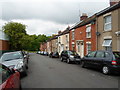
2
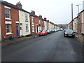
Salisbury Street
Victorian terraces in Semilong.
Image: © Burgess Von Thunen
Taken: 21 Jan 2015
0.07 miles
3
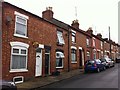
Lower Hester Street
Victorian terraces in Semilong.
Image: © Burgess Von Thunen
Taken: 5 Nov 2015
0.09 miles
4
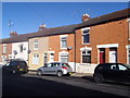
Northcote Street
Victorian terraces in Semilong.
Image: © Burgess Von Thunen
Taken: 17 Sep 2015
0.14 miles
6
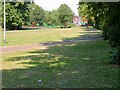
Millers Meadow
Locally known as Paddy's Meadow.
Image: © Kokai
Taken: 19 Jul 2006
0.18 miles
7
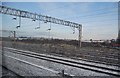
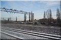
Railway sidings, north of Northampton Station
Image: © N Chadwick
Taken: 19 Dec 2010
0.19 miles
9
Brook Street
Victorian terraces in Semilong.
Image: © Burgess Von Thunen
Taken: 7 Aug 2014
0.20 miles
10
Lower Priory Street
Victorian terraces in Semilong.
Image: © Burgess Von Thunen
Taken: 21 May 2014
0.21 miles