IMAGES TAKEN NEAR TO
Clarendon Close, CORBY, NN18 8DQ
Introduction
This page details the photographs taken nearby to Clarendon Close, NN18 8DQ by members of the Geograph project.
The Geograph project started in 2005 with the aim of publishing, organising and preserving representative images for every square kilometre of Great Britain, Ireland and the Isle of Man.

There are currently over 7.5m images from over14,400 individuals and you can help contribute to the project by visiting https://www.geograph.org.uk
Image Map (Loading...)


Getting Data...Please wait
Leaflet Map data © OpenStreetMap
Images are licensed for reuse under creativecommons.org/licenses/by-sa/2.0
Notes
- Clicking on the map will re-center to the selected point.
- The higher the marker number, the further away the image location is from the centre of the postcode.
Image Listing (6 Images Found)
Images are licensed for reuse under creativecommons.org/licenses/by-sa/2.0
Image
Details
Distance
1
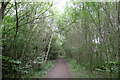
Path through Oakley Purlieus, Corby
The route of Via Devana. Margary (1955, Roman Roads in Britain, vol. 1) states that the course of the Roman road on the south-east side of Corby: "... is first marked by a woodland ride passing north-westward through the extensive woods south of Corby called South Wood and Oakley Purlieus."
Image: © Tim Heaton
Taken: 25 Jul 2023
0.05 miles
2
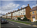
Roman Road, Little Stanion
Has something of the feel of a Victorian seaside terrace.
Image: © Jonathan Thacker
Taken: 2 Sep 2019
0.17 miles
3
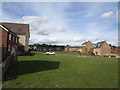
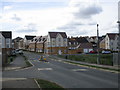
Little Stanion
A new housing area close to Corby.
Image: © Jonathan Thacker
Taken: 2 Sep 2019
0.20 miles
4
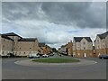
Roman Road, Little Stanion, Corby. View north-west
The street's name reflects its position on the line of the old Roman road, Via Devana. Coming from the south-east, this is the first physical manifestation of the road's route on this side of the River Nene, 8 miles away (Margary, 1955, Roman Roads in Britain, vol. 1)
Image: © Tim Heaton
Taken: 25 Jul 2023
0.20 miles
5
Little Stanion
A new housing area close to Corby.
Image: © Jonathan Thacker
Taken: 2 Sep 2019
0.23 miles
6
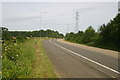
Road up to Euro Hub
Off the A43 near Stanion the road to Euro Hub
Image: © Shaun Ferguson
Taken: 19 Jun 2007
0.24 miles