IMAGES TAKEN NEAR TO
St. James Road, CORBY, NN18 8AL
Introduction
This page details the photographs taken nearby to St. James Road, NN18 8AL by members of the Geograph project.
The Geograph project started in 2005 with the aim of publishing, organising and preserving representative images for every square kilometre of Great Britain, Ireland and the Isle of Man.

There are currently over 7.5m images from over14,400 individuals and you can help contribute to the project by visiting https://www.geograph.org.uk
Image Map (Loading...)


Getting Data...Please wait
Leaflet Map data © OpenStreetMap
Images are licensed for reuse under creativecommons.org/licenses/by-sa/2.0
Notes
- Clicking on the map will re-center to the selected point.
- The higher the marker number, the further away the image location is from the centre of the postcode.
Image Listing (17 Images Found)
Images are licensed for reuse under creativecommons.org/licenses/by-sa/2.0
Image
Details
Distance
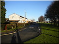
2
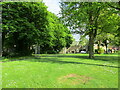
Scott Road, Corby
Parallel to Weldon Road (left) on the southern edge of the Old Village.
Image: © Richard Vince
Taken: 18 Jan 2020
0.07 miles
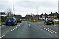
3
Southall Road, Corby
In the southern part of the Old Village.
Image: © Richard Vince
Taken: 18 Jan 2020
0.08 miles
5
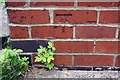
Benchmark on #27 Station Road
Ordnance Survey cut mark benchmark described on the Bench Mark Database at https://www.bench-marks.org.uk/bm100239
Image: © Roger Templeman
Taken: 13 Sep 2018
0.16 miles
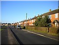
6
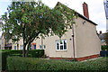
Row of houses on Station Road
There is an OS benchmark Image on the near corner, right hand face, of the nearest house
Image: © Roger Templeman
Taken: 13 Sep 2018
0.17 miles
7
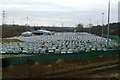
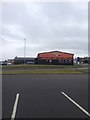
New cars at Eurohub central
This is just one part of a vast parking area used to store new cars.
Image: © Blane Chalmers
Taken: 25 Feb 2007
0.18 miles
10
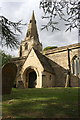
South face and spire of St John the Baptist Church
The spire in an Ordnance Survey intersected station trig point, http://trigpointing.uk/trig/11885
Image: © Roger Templeman
Taken: 13 Sep 2018
0.21 miles