IMAGES TAKEN NEAR TO
Holland Square, Hampstead Road, CORBY, NN17 5GT
Introduction
This page details the photographs taken nearby to Holland Square, Hampstead Road, NN17 5GT by members of the Geograph project.
The Geograph project started in 2005 with the aim of publishing, organising and preserving representative images for every square kilometre of Great Britain, Ireland and the Isle of Man.

There are currently over 7.5m images from over14,400 individuals and you can help contribute to the project by visiting https://www.geograph.org.uk
Image Map
Images are licensed for reuse under creativecommons.org/licenses/by-sa/2.0
Notes
- Clicking on the map will re-center to the selected point.
- The higher the marker number, the further away the image location is from the centre of the postcode.
Image Listing (4 Images Found)
Images are licensed for reuse under creativecommons.org/licenses/by-sa/2.0
Image
Details
Distance
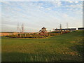
2
Industrial Development.
Major building work in progress on the outskirts of Corby.
Image: © Richard Williams
Taken: 22 May 2007
0.07 miles
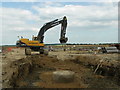
3
Development area, North East Corby
Image: © Jonathan Thacker
Taken: 28 Sep 2020
0.10 miles
4
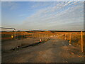
Entrance to construction site
Virtually all the land in this picture is being developed for housing.
Image: © Jonathan Thacker
Taken: 28 Sep 2020
0.17 miles