
IMAGES TAKEN NEAR TO
Prestoe Close, CORBY, NN17 5GF
Introduction
This page details the photographs taken nearby to Prestoe Close, NN17 5GF by members of the Geograph project.
The Geograph project started in 2005 with the aim of publishing, organising and preserving representative images for every square kilometre of Great Britain, Ireland and the Isle of Man.

There are currently over 7.5m images from over14,400 individuals and you can help contribute to the project by visiting https://www.geograph.org.uk
Image Map
Images are licensed for reuse under creativecommons.org/licenses/by-sa/2.0
Notes
- Clicking on the map will re-center to the selected point.
- The higher the marker number, the further away the image location is from the centre of the postcode.
Image Listing (4 Images Found)
Images are licensed for reuse under creativecommons.org/licenses/by-sa/2.0
Image
Details
Distance
2
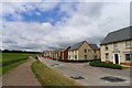
New houses on Flaxland Way, Priors Hall Park
The southern edge of the Priors Hall Park development, dubbed the UK's biggest building site. It involves the provision of "5,100 homes, health facilities, three schools, an academy, district centre, extensive commercial and recreational areas and a network of cycle and pedestrian facilities"
Image: © Tim Heaton
Taken: 20 Jun 2018
0.17 miles
3
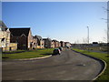
London Road, Priors Hall Park
Along the southern edge of a large housing development on the eastern edge of Corby. The houses here appear complete (and, in many cases, occupied), but the roads still lack a proper surface, hence the raised ironwork visible here.
Image: © Richard Vince
Taken: 18 Jan 2020
0.23 miles
4
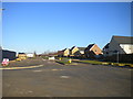
Road along western edge of Priors Hall Park
An apparently anonymous dual carriageway along the edge of a large housing development on the eastern edge of Corby. The houses here appear complete (and, in many cases, occupied), but the roads still lack a proper surface.
Image: © Richard Vince
Taken: 18 Jan 2020
0.24 miles