IMAGES TAKEN NEAR TO
Lindersmith Close, CORBY, NN17 3ND
Introduction
This page details the photographs taken nearby to Lindersmith Close, NN17 3ND by members of the Geograph project.
The Geograph project started in 2005 with the aim of publishing, organising and preserving representative images for every square kilometre of Great Britain, Ireland and the Isle of Man.

There are currently over 7.5m images from over14,400 individuals and you can help contribute to the project by visiting https://www.geograph.org.uk
Image Map
Images are licensed for reuse under creativecommons.org/licenses/by-sa/2.0
Notes
- Clicking on the map will re-center to the selected point.
- The higher the marker number, the further away the image location is from the centre of the postcode.
Image Listing (6 Images Found)
Images are licensed for reuse under creativecommons.org/licenses/by-sa/2.0
Image
Details
Distance
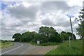
1
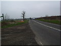
A427 towards Weldon
Approaching Weldon on the A427
Image: © Les Harvey
Taken: 24 Mar 2007
0.11 miles
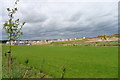
2
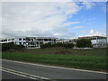
New secondary school under construction, Weldon Park
Part of the vast Weldon Park development.
Image: © Jonathan Thacker
Taken: 10 Sep 2022
0.13 miles
3
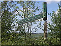
Hanging in there
The bridleway sign is doing its best to hang on despite the abuse it seems to have suffered.
Image: © Michael Trolove
Taken: 12 May 2009
0.18 miles
4
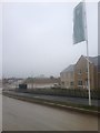
New builds at Weldon
This whole area is being transformed. It isn't open fields any more...
Image: © Dave Thompson
Taken: 25 Feb 2017
0.18 miles
5
Junction of Bears Lane with Oundle Road
The lane gives access to Laundimer Woods and Fermyn Woods; remnants of Rockingham Forest
Image: © Tim Heaton
Taken: 20 Jun 2018
0.19 miles
6
Weldon Park housing development, off Oundle Road, Weldon
A development by Persimmon Homes. One of many new housing estates near Corby
Image: © Tim Heaton
Taken: 20 Jun 2018
0.21 miles