IMAGES TAKEN NEAR TO
Corby Road, CORBY, NN17 3HT
Introduction
This page details the photographs taken nearby to Corby Road, NN17 3HT by members of the Geograph project.
The Geograph project started in 2005 with the aim of publishing, organising and preserving representative images for every square kilometre of Great Britain, Ireland and the Isle of Man.

There are currently over 7.5m images from over14,400 individuals and you can help contribute to the project by visiting https://www.geograph.org.uk
Image Map
Images are licensed for reuse under creativecommons.org/licenses/by-sa/2.0
Notes
- Clicking on the map will re-center to the selected point.
- The higher the marker number, the further away the image location is from the centre of the postcode.
Image Listing (7 Images Found)
Images are licensed for reuse under creativecommons.org/licenses/by-sa/2.0
Image
Details
Distance
1
Driveway off Water Lane, Weldon
Also hosting a public footpath.
Image: © Richard Vince
Taken: 18 Jan 2020
0.16 miles
2
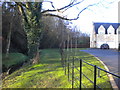
Public footpath, Weldon
Relegated to a muddy, somewhat precipitous course alongside a stream (left) by recent housing development.
Image: © Richard Vince
Taken: 18 Jan 2020
0.20 miles
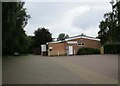
3
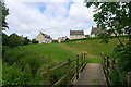
Footpath leading to new houses on Kings Road, Weldon
The path connects the Church of St Mary to the main part of Weldon
Image: © Tim Heaton
Taken: 20 Jun 2018
0.23 miles
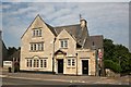
4
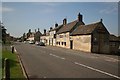
High Street
The old A43 through Weldon with the Woolpack pub on the right
Image: © Richard Croft
Taken: 23 Aug 2007
0.23 miles
6
Oddfellows Hall
Former Oddfellows Hall on Weldon High Street dated 1890, now a private house
Image: © Richard Croft
Taken: 23 Aug 2007
0.24 miles
7
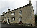
27 High Street, Weldon
Seventeenth/eighteenth century house https://historicengland.org.uk/listing/the-list/list-entry/1051691?section=official-list-entry
Image: © Jonathan Thacker
Taken: 10 Sep 2022
0.24 miles