IMAGES TAKEN NEAR TO
Scott Road, CORBY, NN17 1UH
Introduction
This page details the photographs taken nearby to Scott Road, NN17 1UH by members of the Geograph project.
The Geograph project started in 2005 with the aim of publishing, organising and preserving representative images for every square kilometre of Great Britain, Ireland and the Isle of Man.

There are currently over 7.5m images from over14,400 individuals and you can help contribute to the project by visiting https://www.geograph.org.uk
Image Map (Loading...)


Getting Data...Please wait
Leaflet Map data © OpenStreetMap
Images are licensed for reuse under creativecommons.org/licenses/by-sa/2.0
Notes
- Clicking on the map will re-center to the selected point.
- The higher the marker number, the further away the image location is from the centre of the postcode.
Image Listing (32 Images Found)
Images are licensed for reuse under creativecommons.org/licenses/by-sa/2.0
Image
Details
Distance
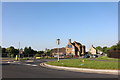
1
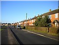
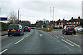
Scott Road, Corby
Parallel to Weldon Road (left) on the southern edge of the Old Village.
Image: © Richard Vince
Taken: 18 Jan 2020
0.04 miles
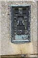
2
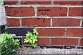
Benchmark on #27 Station Road
Ordnance Survey cut mark benchmark described on the Bench Mark Database at https://www.bench-marks.org.uk/bm100239
Image: © Roger Templeman
Taken: 13 Sep 2018
0.07 miles
3
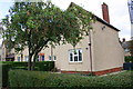
Row of houses on Station Road
There is an OS benchmark Image on the near corner, right hand face, of the nearest house
Image: © Roger Templeman
Taken: 13 Sep 2018
0.07 miles
4
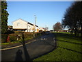
Southall Road, Corby
In the southern part of the Old Village.
Image: © Richard Vince
Taken: 18 Jan 2020
0.07 miles
7
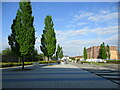
Space in front of the railway station, Corby
The station seems somewhat isolated from the town. A few substantial buildings around this space would add to its presence.
Image: © Jonathan Thacker
Taken: 8 May 2022
0.14 miles
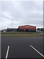
8
Stagecoach bus garage on Station Road, Corby
Image: © David Howard
Taken: 29 Jun 2019
0.15 miles
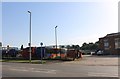
9
Cottingham Road at the junction of Station Road
Image: © David Howard
Taken: 29 Jun 2019
0.15 miles
10
Benchmark on the White Hart
Ordnance Survey flush bracket (serial identifier S8748) benchmark described on the Bench Mark Database at https://www.bench-marks.org.uk/bm12607
Image: © Roger Templeman
Taken: 13 Sep 2018
0.16 miles