IMAGES TAKEN NEAR TO
West View, CORBY, NN17 1AS
Introduction
This page details the photographs taken nearby to West View, NN17 1AS by members of the Geograph project.
The Geograph project started in 2005 with the aim of publishing, organising and preserving representative images for every square kilometre of Great Britain, Ireland and the Isle of Man.

There are currently over 7.5m images from over14,400 individuals and you can help contribute to the project by visiting https://www.geograph.org.uk
Image Map
Images are licensed for reuse under creativecommons.org/licenses/by-sa/2.0
Notes
- Clicking on the map will re-center to the selected point.
- The higher the marker number, the further away the image location is from the centre of the postcode.
Image Listing (28 Images Found)
Images are licensed for reuse under creativecommons.org/licenses/by-sa/2.0
Image
Details
Distance
1
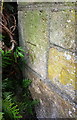
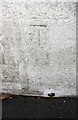
Benchmark on bridge on east side of The Jamb
Ordnance Survey cut mark benchmark described on the Bench Mark Database at https://www.bench-marks.org.uk/bm100296
Image: © Roger Templeman
Taken: 13 Sep 2018
0.09 miles
2
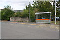
Bridge parapet and bus stop shelter on east side of The Jamb
There is an OS benchmark Image at the left hand end (road face) of the parapet
Image: © Roger Templeman
Taken: 13 Sep 2018
0.09 miles
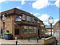
3
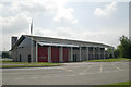
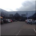
Corby fire station
Corby fire station, Phoenix Parkway, Corby, Northamptonshire
Image: © Kevin Hale
Taken: 31 May 2008
0.10 miles
4
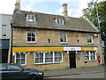
57 High Street, Corby
Eighteenth century house now offices https://historicengland.org.uk/listing/the-list/list-entry/1192010?section=official-list-entry
Image: © Jonathan Thacker
Taken: 8 May 2022
0.10 miles
5
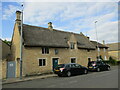
The former Manor Farm, Corby
Dated 1609 https://historicengland.org.uk/listing/the-list/list-entry/1372548?section=official-list-entry
Image: © Jonathan Thacker
Taken: 8 May 2022
0.11 miles
6
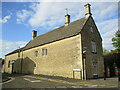
The Old Schoolhouse, Corby
Dates from the mid eighteenth century. The building at the rear was added later and was once a chapel. https://historicengland.org.uk/listing/the-list/list-entry/1051777?section=official-list-entry
Image: © Jonathan Thacker
Taken: 8 May 2022
0.12 miles
7
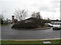
Corby
A roundabout on a retail park in Corby.
Image: © Burgess Von Thunen
Taken: 16 Dec 2011
0.14 miles
10
Benchmark on Rockingham Road railway bridge
Ordnance Survey cut mark benchmark described on the Bench Mark Database at https://www.bench-marks.org.uk/bm100238
Image: © Roger Templeman
Taken: 13 Sep 2018
0.15 miles