IMAGES TAKEN NEAR TO
Stanier Close, KETTERING, NN16 9XW
Introduction
This page details the photographs taken nearby to Stanier Close, NN16 9XW by members of the Geograph project.
The Geograph project started in 2005 with the aim of publishing, organising and preserving representative images for every square kilometre of Great Britain, Ireland and the Isle of Man.

There are currently over 7.5m images from over14,400 individuals and you can help contribute to the project by visiting https://www.geograph.org.uk
Image Map
Images are licensed for reuse under creativecommons.org/licenses/by-sa/2.0
Notes
- Clicking on the map will re-center to the selected point.
- The higher the marker number, the further away the image location is from the centre of the postcode.
Image Listing (7 Images Found)
Images are licensed for reuse under creativecommons.org/licenses/by-sa/2.0
Image
Details
Distance
1
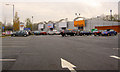
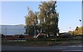
Retail park Northfield Avenue Kettering
Image: © Steve Fareham
Taken: 21 Nov 2007
0.16 miles
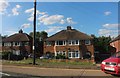
2
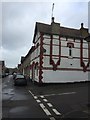
House in Kettering
On the corner of Leicester and Cobden Street.
Image: © Dave Thompson
Taken: 13 Mar 2019
0.19 miles
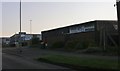
3
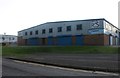
PCS IT support on Northfield Avenue, Kettering
Image: © David Howard
Taken: 13 Sep 2020
0.20 miles
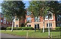
7
Northfield Avenue, Kettering
By the Cunliffe Road industrial estate
Image: © David Howard
Taken: 13 Sep 2020
0.24 miles