IMAGES TAKEN NEAR TO
Cambium Close, KETTERING, NN16 9US
Introduction
This page details the photographs taken nearby to Cambium Close, NN16 9US by members of the Geograph project.
The Geograph project started in 2005 with the aim of publishing, organising and preserving representative images for every square kilometre of Great Britain, Ireland and the Isle of Man.

There are currently over 7.5m images from over14,400 individuals and you can help contribute to the project by visiting https://www.geograph.org.uk
Image Map
Images are licensed for reuse under creativecommons.org/licenses/by-sa/2.0
Notes
- Clicking on the map will re-center to the selected point.
- The higher the marker number, the further away the image location is from the centre of the postcode.
Image Listing (7 Images Found)
Images are licensed for reuse under creativecommons.org/licenses/by-sa/2.0
Image
Details
Distance
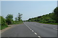
2
A43 Kettering bypass, 2
Looking east from the layby, in the direction of Corby.
Image: © Jonathan Billinger
Taken: 14 Dec 2013
0.11 miles
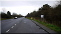
3
The Kettering Bypass
This has just been renumbered the A6183 from the A4300, which in turn was the A43.
Image: © David Howard
Taken: 13 Sep 2020
0.13 miles
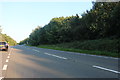
4
A43 Kettering bypass
Looking west towards the footpath entrance to Weekley Hall Wood.
Image: © Jonathan Billinger
Taken: 14 Dec 2013
0.17 miles
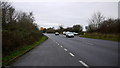
5
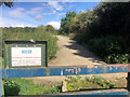
Bridleway off the A6183
Bridleway accessed from a layby on the A6183. Warning notice on the barrier.
Image: © David Dixon
Taken: 18 Sep 2017
0.17 miles

7
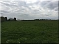
View towards Kettering Business Park
The nice fields at the back of the Harvester/Holiday Inn in Kettering. By 2018 this view is likely to have been irreparably changed by some huge warehouses planned for the area.
Image: © Local Photographer
Taken: 28 Apr 2017
0.23 miles