IMAGES TAKEN NEAR TO
Stamford Road, KETTERING, NN16 9SU
Introduction
This page details the photographs taken nearby to Stamford Road, NN16 9SU by members of the Geograph project.
The Geograph project started in 2005 with the aim of publishing, organising and preserving representative images for every square kilometre of Great Britain, Ireland and the Isle of Man.

There are currently over 7.5m images from over14,400 individuals and you can help contribute to the project by visiting https://www.geograph.org.uk
Image Map
Images are licensed for reuse under creativecommons.org/licenses/by-sa/2.0
Notes
- Clicking on the map will re-center to the selected point.
- The higher the marker number, the further away the image location is from the centre of the postcode.
Image Listing (12 Images Found)
Images are licensed for reuse under creativecommons.org/licenses/by-sa/2.0
Image
Details
Distance
7
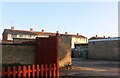
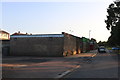
Loading area behind the shops on Stamford Road, Kettering
Image: © David Howard
Taken: 13 Sep 2020
0.19 miles
8
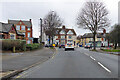
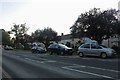
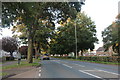
A6098 Windmill Avenue, Kettering
Ahead is the junction with the A4300, Stamford Road.
Image: © Robin Webster
Taken: 5 Dec 2021
0.19 miles
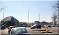
9
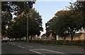
Stamford Road, Kettering
The Co-op is on the left
Image: © David Howard
Taken: 13 Sep 2020
0.20 miles