IMAGES TAKEN NEAR TO
Rockingham Road, KETTERING, NN16 9JB
Introduction
This page details the photographs taken nearby to Rockingham Road, NN16 9JB by members of the Geograph project.
The Geograph project started in 2005 with the aim of publishing, organising and preserving representative images for every square kilometre of Great Britain, Ireland and the Isle of Man.

There are currently over 7.5m images from over14,400 individuals and you can help contribute to the project by visiting https://www.geograph.org.uk
Image Map
Images are licensed for reuse under creativecommons.org/licenses/by-sa/2.0
Notes
- Clicking on the map will re-center to the selected point.
- The higher the marker number, the further away the image location is from the centre of the postcode.
Image Listing (11 Images Found)
Images are licensed for reuse under creativecommons.org/licenses/by-sa/2.0
Image
Details
Distance
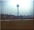
1
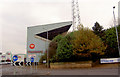
Home of The Poppies
Kettering Town F C
http://www.ketteringtownfc.co.uk/
Image: © Steve Fareham
Taken: 21 Nov 2007
0.10 miles
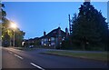
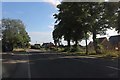
2
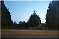
Small park on Rockingham Road, Kettering
Image: © David Howard
Taken: 8 May 2022
0.13 miles
3
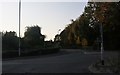
Road junction Northfield Avenue and Rockingham Road
Image: © John Firth
Taken: 13 Sep 2010
0.14 miles
4
Rockingham Road Football Ground
Rockingham Road is the former home of Kettering Town Football Club.
Image: © Steve Daniels
Taken: 20 Nov 1976
0.15 miles
6
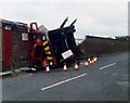
Kettering Football Ground and Crane
I took this in 1982 when a crane tipped over and crashed through the wall of the football ground at Kettering.
Image: © Nick Mutton 01329 000000
Taken: 1 Jan 1982
0.18 miles
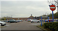
9
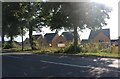
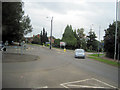
New houses on Rockingham Road, Kettering
Image: © David Howard
Taken: 29 Jul 2019
0.21 miles