IMAGES TAKEN NEAR TO
Thorn Close, KETTERING, NN16 9BU
Introduction
This page details the photographs taken nearby to Thorn Close, NN16 9BU by members of the Geograph project.
The Geograph project started in 2005 with the aim of publishing, organising and preserving representative images for every square kilometre of Great Britain, Ireland and the Isle of Man.

There are currently over 7.5m images from over14,400 individuals and you can help contribute to the project by visiting https://www.geograph.org.uk
Image Map
Images are licensed for reuse under creativecommons.org/licenses/by-sa/2.0
Notes
- Clicking on the map will re-center to the selected point.
- The higher the marker number, the further away the image location is from the centre of the postcode.
Image Listing (3 Images Found)
Images are licensed for reuse under creativecommons.org/licenses/by-sa/2.0
Image
Details
Distance
1
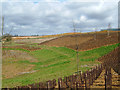
Landscaping the River Slade valley, Kettering
In the distance is the developing North Kettering Business Park. The photo was taken from a horse-rider's path being added to the amenities.
Image: © John Stolarski
Taken: 17 Apr 2006
0.21 miles
3
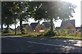
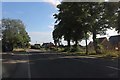
New houses on Rockingham Road, Kettering
Image: © David Howard
Taken: 29 Jul 2019
0.24 miles