IMAGES TAKEN NEAR TO
Bath Road, KETTERING, NN16 8NB
Introduction
This page details the photographs taken nearby to Bath Road, NN16 8NB by members of the Geograph project.
The Geograph project started in 2005 with the aim of publishing, organising and preserving representative images for every square kilometre of Great Britain, Ireland and the Isle of Man.

There are currently over 7.5m images from over14,400 individuals and you can help contribute to the project by visiting https://www.geograph.org.uk
Image Map
Images are licensed for reuse under creativecommons.org/licenses/by-sa/2.0
Notes
- Clicking on the map will re-center to the selected point.
- The higher the marker number, the further away the image location is from the centre of the postcode.
Image Listing (15 Images Found)
Images are licensed for reuse under creativecommons.org/licenses/by-sa/2.0
Image
Details
Distance
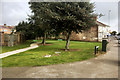
4
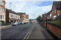
Lawson Street at the junction of Stamford Road
Image: © David Howard
Taken: 13 Sep 2020
0.15 miles
5
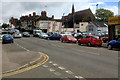
Montagu Street, Kettering
Montagu Street, outside Caswell's furniture store.
Image: © David Dixon
Taken: 16 Sep 2017
0.17 miles
6
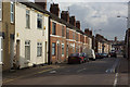
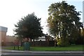
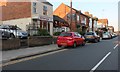
Bath Road, Kettering
Terraced housing typical of this area to the immediate north-east of the town centre.
Image: © Stephen McKay
Taken: 20 Jun 2007
0.17 miles
7
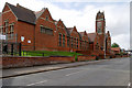
Kettering, The William Knibb Centre
The William Knibb Centre is an imposing building, owned by Northamptonshire County Council, which currently has multiple users, including office space for NCC staff. It is named after William Knibb (1803 – 1845) who was a Baptist minister and missionary to Jamaica. Born in Kettering, he is chiefly known today for his work to free slaves.
Image: © David Dixon
Taken: 16 Sep 2017
0.18 miles
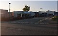
8
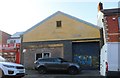
Unusual building on Montagu Street, Kettering
It looks like some sort of workshop. As with so many shops and the like they were built in the front gardens of mainly Victorian houses, which can clearly be seen at the back. North London has hundreds like this along the main roads.
Image: © David Howard
Taken: 13 Sep 2020
0.19 miles
9
Montagu Street, Kettering
If anyone's curious Mont Agu is French for sharp mountain.
Image: © David Howard
Taken: 13 Sep 2020
0.19 miles
10
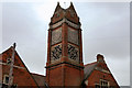
William Knibb Centre (Tower)
The William Knibb Centre, on Montagu Street, is an imposing building, owned by Northamptonshire County Council, which currently has multiple users, including office space for NCC staff. It is named after William Knibb (1803 – 1845) who was a Baptist minister and missionary to Jamaica. Born in Kettering, he is chiefly known today for his work to free slaves.
See also Image
Image: © David Dixon
Taken: 16 Sep 2017
0.20 miles