IMAGES TAKEN NEAR TO
Buttermere Close, KETTERING, NN16 8LZ
Introduction
This page details the photographs taken nearby to Buttermere Close, NN16 8LZ by members of the Geograph project.
The Geograph project started in 2005 with the aim of publishing, organising and preserving representative images for every square kilometre of Great Britain, Ireland and the Isle of Man.

There are currently over 7.5m images from over14,400 individuals and you can help contribute to the project by visiting https://www.geograph.org.uk
Image Map
Images are licensed for reuse under creativecommons.org/licenses/by-sa/2.0
Notes
- Clicking on the map will re-center to the selected point.
- The higher the marker number, the further away the image location is from the centre of the postcode.
Image Listing (16 Images Found)
Images are licensed for reuse under creativecommons.org/licenses/by-sa/2.0
Image
Details
Distance
2
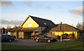
Kettering General Hospital Community Diabetes Centre
Looking north from the car park.
Image: © John Winterbottom
Taken: 26 Jan 2006
0.15 miles
3
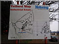
Sign of the map of Telford Way Industrial Estate, Kettering
Image: © James Haynes
Taken: 4 Jan 2009
0.17 miles
4
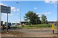
Retail park by Rothwell Road, Kettering
Image: © David Howard
Taken: 29 Jul 2019
0.17 miles
5

A14 near Brooklands Farm
Although the general direction of this carriageway of the A14 is east, at this point it heads almost due south as the route circumvents Kettering.
Image: © Peter Whatley
Taken: 27 Jul 2013
0.20 miles
7
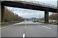
Eastbound A14
Actually heading south here, as the road rounds Kettering.
Image: © Robin Webster
Taken: 5 Dec 2021
0.20 miles