IMAGES TAKEN NEAR TO
Mill Road, KETTERING, NN16 0RY
Introduction
This page details the photographs taken nearby to Mill Road, NN16 0RY by members of the Geograph project.
The Geograph project started in 2005 with the aim of publishing, organising and preserving representative images for every square kilometre of Great Britain, Ireland and the Isle of Man.

There are currently over 7.5m images from over14,400 individuals and you can help contribute to the project by visiting https://www.geograph.org.uk
Image Map
Images are licensed for reuse under creativecommons.org/licenses/by-sa/2.0
Notes
- Clicking on the map will re-center to the selected point.
- The higher the marker number, the further away the image location is from the centre of the postcode.
Image Listing (29 Images Found)
Images are licensed for reuse under creativecommons.org/licenses/by-sa/2.0
Image
Details
Distance
4
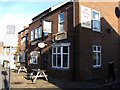
The Earl of Dalkeith Kettering
A Wetherspoon pub in Silver Street
Image: © John Firth
Taken: 13 Sep 2010
0.13 miles
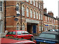
5
Kettering - Central Methodist Church
On School Lane.
Image: © Dave Bevis
Taken: 6 Apr 2012
0.13 miles
7
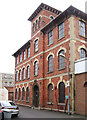
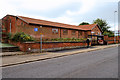
Gladstone St Kettering
Former shoe factory converted to apartments
Image: © John Stolarski
Taken: 28 Apr 2003
0.14 miles
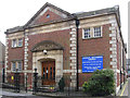
9
Kettering Kingdom Hall, Montagu Street
Jehovah's Witnesses use Kingdom Halls for the majority of their worship and Bible instruction. Witnesses prefer the term "Kingdom Hall" over "church", regarding the term "church" as referring to the congregation of people rather than the building.
Image: © David Dixon
Taken: 16 Sep 2017
0.15 miles
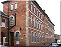
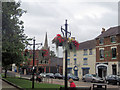
10
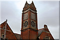
William Knibb Centre (Tower)
The William Knibb Centre, on Montagu Street, is an imposing building, owned by Northamptonshire County Council, which currently has multiple users, including office space for NCC staff. It is named after William Knibb (1803 – 1845) who was a Baptist minister and missionary to Jamaica. Born in Kettering, he is chiefly known today for his work to free slaves.
See also Image
Image: © David Dixon
Taken: 16 Sep 2017
0.16 miles