IMAGES TAKEN NEAR TO
Mill Road, KETTERING, NN16 0RJ
Introduction
This page details the photographs taken nearby to Mill Road, NN16 0RJ by members of the Geograph project.
The Geograph project started in 2005 with the aim of publishing, organising and preserving representative images for every square kilometre of Great Britain, Ireland and the Isle of Man.

There are currently over 7.5m images from over14,400 individuals and you can help contribute to the project by visiting https://www.geograph.org.uk
Image Map
Images are licensed for reuse under creativecommons.org/licenses/by-sa/2.0
Notes
- Clicking on the map will re-center to the selected point.
- The higher the marker number, the further away the image location is from the centre of the postcode.
Image Listing (19 Images Found)
Images are licensed for reuse under creativecommons.org/licenses/by-sa/2.0
Image
Details
Distance
3
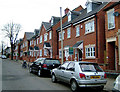
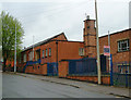
Gladstone St Kettering
Former shoe factory converted to apartments
Image: © John Stolarski
Taken: 28 Apr 2003
0.18 miles
4
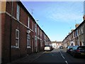
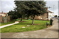
Housing on site of former shoe factory, St Peter's Ave Kettering.
This shows the site three years after the photo of the factory was taken. I had identified the factory as being one of Loake's, but I now think it was one of Griggs'. Can anyone provide information?
Note also the effects of a cold spring in 2006 on the tree: this photo was taken mid-April; the older one near the end of April.
Image: © John Stolarski
Taken: 12 Apr 2006
0.19 miles
5
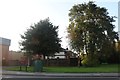
Shoe factory, Kettering
Factory on St Peter's Avenue, closed 2002. Now demolished and replaced by high-density housing. (See this on another photo.) Kettering is dotted with former shoe factories and leather works which have closed and been demolished for, or converted to, housing.
Image: © John Stolarski
Taken: 28 Apr 2003
0.19 miles
8
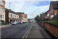
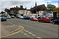
Montagu Street, Kettering
Montagu Street, outside Caswell's furniture store.
Image: © David Dixon
Taken: 16 Sep 2017
0.20 miles
9
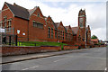
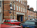
Kettering, The William Knibb Centre
The William Knibb Centre is an imposing building, owned by Northamptonshire County Council, which currently has multiple users, including office space for NCC staff. It is named after William Knibb (1803 – 1845) who was a Baptist minister and missionary to Jamaica. Born in Kettering, he is chiefly known today for his work to free slaves.
Image: © David Dixon
Taken: 16 Sep 2017
0.20 miles
10
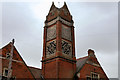
William Knibb Centre (Tower)
The William Knibb Centre, on Montagu Street, is an imposing building, owned by Northamptonshire County Council, which currently has multiple users, including office space for NCC staff. It is named after William Knibb (1803 – 1845) who was a Baptist minister and missionary to Jamaica. Born in Kettering, he is chiefly known today for his work to free slaves.
See also Image
Image: © David Dixon
Taken: 16 Sep 2017
0.20 miles