IMAGES TAKEN NEAR TO
Saunders Close, KETTERING, NN16 0AP
Introduction
This page details the photographs taken nearby to Saunders Close, NN16 0AP by members of the Geograph project.
The Geograph project started in 2005 with the aim of publishing, organising and preserving representative images for every square kilometre of Great Britain, Ireland and the Isle of Man.

There are currently over 7.5m images from over14,400 individuals and you can help contribute to the project by visiting https://www.geograph.org.uk
Image Map
Images are licensed for reuse under creativecommons.org/licenses/by-sa/2.0
Notes
- Clicking on the map will re-center to the selected point.
- The higher the marker number, the further away the image location is from the centre of the postcode.
Image Listing (93 Images Found)
Images are licensed for reuse under creativecommons.org/licenses/by-sa/2.0
Image
Details
Distance
1
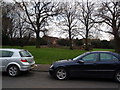
A view of Meadow Road Park taken from Meadow Road
Image: © James Haynes
Taken: 3 Jan 2009
0.03 miles
2
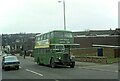
Bristol KSW type bus, Kettering ? 1973
This type of bus had been the mainstay of the nationalised Transport Holding Company subsidiaries through the 1950s, but had become a rarity by the early 1970s. United Counties 967, new in 1954, had only a few weeks more to run before withdrawal. It is seen here on Station Road outside the bus garage. The destination 'L M R Station' is a relic of the previous designation as 'L M S Station', but in fact there was only ever the one station in the town.
This is one of a series of views featuring buses in the 60s, 70s, and 80s. http://www.geograph.org.uk/search.php?i=137652761
Image: © Alan Murray-Rust
Taken: 3 Mar 1973
0.07 miles
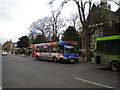
4
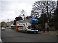
Bus near Kettering Market Place
The northernmost bus stops on Sheep Street, Kettering (see also Image), are located close to the Market Place, which can be seen in the background on the left. The X4 is a very long route, linking Peterborough with Milton Keynes via Corby, Kettering, Wellingborough and Northampton; this bus appears to be operating one of the Corby to Northampton short workings.
Image: © Richard Vince
Taken: 6 Mar 2010
0.10 miles
5
Bus on Sheep Street, Kettering
Although there is a small bus station on Eskdaill Street, many buses that serve Kettering (particularly those from north of the town) terminate on Sheep Street outside the library, the north end of which is visible between the buses. The 19 to Desborough, pictured here, is one such route.
Image: © Richard Vince
Taken: 6 Mar 2010
0.10 miles
6
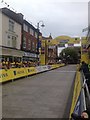
Finish Line
The Women's Tour of Britain 2015 finished in Kettering. This is a view of the finish line.
Image: © Dave Thompson
Taken: 19 Jun 2015
0.10 miles
7
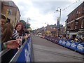
Finishing Straight
The Women's Tour of Britain 2015 finished in Kettering. This is a view of the finishing straight.
Image: © Dave Thompson
Taken: 19 Jun 2015
0.10 miles
8
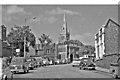
Kettering: Station Road, 1962
View NE, to Church of St Peter and St Paul
Image: © Ben Brooksbank
Taken: 4 Jun 1962
0.10 miles
9
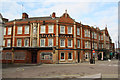
The Royal Hotel
Grade II listed, neo-Jacobean hotel built 1878 on the site of the White Hart Hotel.
Image: © Richard Croft
Taken: 30 Jan 2012
0.11 miles
10
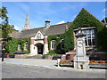
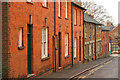
Kettering Public Library
On Sheep Street.
Image: © Burgess Von Thunen
Taken: 29 Aug 2013
0.11 miles