IMAGES TAKEN NEAR TO
Melbourne Walk, NORTHAMPTON, NN1 5SL
Introduction
This page details the photographs taken nearby to Melbourne Walk, NN1 5SL by members of the Geograph project.
The Geograph project started in 2005 with the aim of publishing, organising and preserving representative images for every square kilometre of Great Britain, Ireland and the Isle of Man.

There are currently over 7.5m images from over14,400 individuals and you can help contribute to the project by visiting https://www.geograph.org.uk
Image Map
Images are licensed for reuse under creativecommons.org/licenses/by-sa/2.0
Notes
- Clicking on the map will re-center to the selected point.
- The higher the marker number, the further away the image location is from the centre of the postcode.
Image Listing (56 Images Found)
Images are licensed for reuse under creativecommons.org/licenses/by-sa/2.0
Image
Details
Distance
1
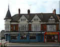
The Old House
Now a public house, but this does not appear to have been its original function; it was presumably formerly just ordinary retail premises.
Image: © Alan Murray-Rust
Taken: 3 Aug 2011
0.06 miles
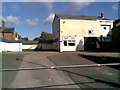
2
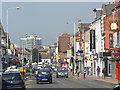
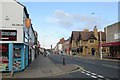
Wellingborough Road
Looking toward the town centre from near Barry Road.
Image: © Alan Murray-Rust
Taken: 3 Aug 2011
0.06 miles
3
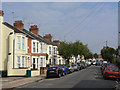
Adams Avenue
Middle class terraced housing off Wellingborough Road.
Image: © Alan Murray-Rust
Taken: 3 Aug 2011
0.06 miles
4
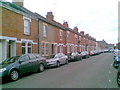
Wilby Street
Victorian terraces in Abington.
Image: © Burgess Von Thunen
Taken: 1 Jul 2011
0.07 miles
5
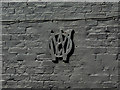
V O W
This unusual monogram on the side of a building appears to be simply the end plate of a tie road. The relevance of the monogram is unclear.
Image: © Alan Murray-Rust
Taken: 3 Aug 2011
0.07 miles
6
Autocare
A vacant car-sales lot on Wellingborough Road.
Image: © Burgess Von Thunen
Taken: 9 Sep 2011
0.08 miles
7
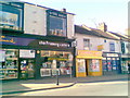
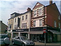
Wellingborough Road
A greeting card shop, framing shop, general store and sex shop in Abington.
Image: © Burgess Von Thunen
Taken: 9 May 2011
0.08 miles
8
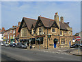
Building on the corner of Wellingborough Road and Whitworth Road
Old maps simply list this as 'Hall', so the original function is unclear. The nearer part was at one stage labelled as 'Bank'; now a restaurant.
Image: © Alan Murray-Rust
Taken: 3 Aug 2011
0.08 miles
9
Northampton: Wellingborough Road
Looking towards the town centre early on a Monday morning in August. Alan Murray-Rust's Image] is a closer view of the extravagant Victorian stone building on the other side of the road - quite a contrast with the supermarket next to it.
Image: © John Sutton
Taken: 18 Aug 2014
0.08 miles
10
Wellingborough Road
Two Seasons is a skateboarding snowsports clothing shop. TS2 is high street fashion.
Image: © Burgess Von Thunen
Taken: 26 Apr 2011
0.08 miles