IMAGES TAKEN NEAR TO
Backley Close, KETTERING, NN15 7RL
Introduction
This page details the photographs taken nearby to Backley Close, NN15 7RL by members of the Geograph project.
The Geograph project started in 2005 with the aim of publishing, organising and preserving representative images for every square kilometre of Great Britain, Ireland and the Isle of Man.

There are currently over 7.5m images from over14,400 individuals and you can help contribute to the project by visiting https://www.geograph.org.uk
Image Map
Images are licensed for reuse under creativecommons.org/licenses/by-sa/2.0
Notes
- Clicking on the map will re-center to the selected point.
- The higher the marker number, the further away the image location is from the centre of the postcode.
Image Listing (8 Images Found)
Images are licensed for reuse under creativecommons.org/licenses/by-sa/2.0
Image
Details
Distance
1
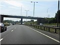
A14 at the southbound A43 junction, Kettering
Image: © Peter Whatley
Taken: 27 Jul 2013
0.10 miles
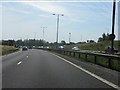
2

Eastbound A14, A43 Flyover at Junction 8
Image: © David Dixon
Taken: 1 Aug 2013
0.10 miles
4
The Trading Post
A public house/restaurant on Northampton Road (A6013) on the outskirts of Kettering.
Image: © James Allan
Taken: 7 Jun 2014
0.12 miles
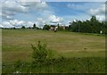
5
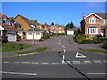
Lake Avenue, Kettering
Facing towards Mead Road on the right. This road takes you to the Kettering Athletics Club, KLV and Golf Course.
Image: © David Tucker
Taken: 13 Mar 2007
0.14 miles
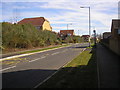
6
Mead Road, Kettering
Taken from Lake Avenue
Image: © David Tucker
Taken: 13 Mar 2007
0.17 miles
7
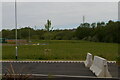
Looking towards the A14 from the business park at the A43 junction
Image: © Christopher Hilton
Taken: 29 May 2021
0.22 miles
8
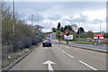
A43 heading south towards Northampton
The lights are for a commercial estate off to the right.
Image: © Robin Webster
Taken: 5 Dec 2021
0.24 miles