IMAGES TAKEN NEAR TO
Bowling Green Road, KETTERING, NN15 7QN
Introduction
This page details the photographs taken nearby to Bowling Green Road, NN15 7QN by members of the Geograph project.
The Geograph project started in 2005 with the aim of publishing, organising and preserving representative images for every square kilometre of Great Britain, Ireland and the Isle of Man.

There are currently over 7.5m images from over14,400 individuals and you can help contribute to the project by visiting https://www.geograph.org.uk
Image Map
Images are licensed for reuse under creativecommons.org/licenses/by-sa/2.0
Notes
- Clicking on the map will re-center to the selected point.
- The higher the marker number, the further away the image location is from the centre of the postcode.
Image Listing (74 Images Found)
Images are licensed for reuse under creativecommons.org/licenses/by-sa/2.0
Image
Details
Distance
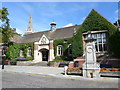
1
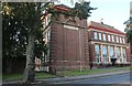
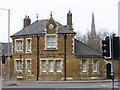
Kettering Council building
It is symmetrical on the other part as well.
Image: © David Howard
Taken: 13 Sep 2020
0.03 miles
3
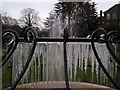
Icicles on a frozen water feature in the gardens near to the Alfred East Art gallery, Kettering
Image: © James Haynes
Taken: 4 Jan 2009
0.04 miles
4
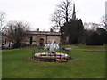
Frozen water feature with the Alfred East Art gallery and the church in the background, Kettering
Image: © James Haynes
Taken: 4 Jan 2009
0.04 miles
5
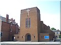
St Edward's Roman Catholic Church, Kettering
Image: © Geoff Pick
Taken: 3 Aug 2011
0.06 miles
6
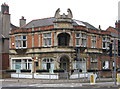
Kettering - Speight's
At junction of London Road and Bowling Green Green. Charles Speight built this as a photographic studio in 1886 (see http://www.kettering.gov.uk/info/200070/museums_and_galleries/101/a_walk_in_and_around_the_manor_house_museum_gardens/10 ). The building is now used as the Gateway Community Church.
Image: © Dave Bevis
Taken: 6 Apr 2012
0.06 miles
7
Kettering - house at junction of London Road and Bowling Green Road
Image: © Dave Bevis
Taken: 6 Apr 2012
0.07 miles
8
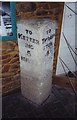
Old Milestone in Kettering Manor House Museum, Sheep Street
Carved stone post was on A6003 (old A6), in parish of Kettering (Kettering District), now in Kettering Manor House Museum, Sheep Street, was on old A6. Kettering stone erected by the Market Harborough & Brampton turnpike trust in the 19th century.
Inscription reads:-
: TO / KETTER / ING / 5 / MILES : : TO / THRAP / STON / 4 / MILES :
The Manor House Museum is Grade II* listed.
List Entry Number: 1189094 https://historicengland.org.uk/listing/the-list/list-entry/1189094
Milestone Society National ID: NR_KTTH05
Image: © Helen Crabtree
Taken: Unknown
0.09 miles
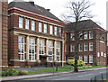
9
Kettering Public Library
On Sheep Street.
Image: © Burgess Von Thunen
Taken: 29 Aug 2013
0.10 miles
10
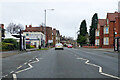
A6003 London Road, Kettering
Towards the town centre.
Image: © Robin Webster
Taken: 5 Dec 2021
0.10 miles