IMAGES TAKEN NEAR TO
London Road, KETTERING, NN15 7QB
Introduction
This page details the photographs taken nearby to London Road, NN15 7QB by members of the Geograph project.
The Geograph project started in 2005 with the aim of publishing, organising and preserving representative images for every square kilometre of Great Britain, Ireland and the Isle of Man.

There are currently over 7.5m images from over14,400 individuals and you can help contribute to the project by visiting https://www.geograph.org.uk
Image Map
Images are licensed for reuse under creativecommons.org/licenses/by-sa/2.0
Notes
- Clicking on the map will re-center to the selected point.
- The higher the marker number, the further away the image location is from the centre of the postcode.
Image Listing (34 Images Found)
Images are licensed for reuse under creativecommons.org/licenses/by-sa/2.0
Image
Details
Distance
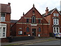

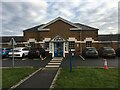
6
Kettering - hospital reception
Off London Road.
Image: © Dave Bevis
Taken: 6 Apr 2012
0.04 miles
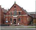
7
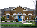
Former Kettering Work House
Remains of the former Kettering Work House, which now form part of St. Mary's Hospital.
Image: © Ajay Tegala
Taken: 3 Dec 2019
0.04 miles
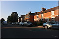
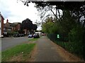
9
Terraced houses on London Road, Kettering
They may have been railway cottages as the station is round the corner.
Image: © David Howard
Taken: 13 Sep 2020
0.06 miles
10
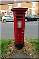
George VI postbox on London Road
Postbox No. NN15 39.
Image: © JThomas
Taken: 21 Sep 2022
0.06 miles