IMAGES TAKEN NEAR TO
Ovett Close, KETTERING, NN15 7EQ
Introduction
This page details the photographs taken nearby to Ovett Close, NN15 7EQ by members of the Geograph project.
The Geograph project started in 2005 with the aim of publishing, organising and preserving representative images for every square kilometre of Great Britain, Ireland and the Isle of Man.

There are currently over 7.5m images from over14,400 individuals and you can help contribute to the project by visiting https://www.geograph.org.uk
Image Map
Images are licensed for reuse under creativecommons.org/licenses/by-sa/2.0
Notes
- Clicking on the map will re-center to the selected point.
- The higher the marker number, the further away the image location is from the centre of the postcode.
Image Listing (13 Images Found)
Images are licensed for reuse under creativecommons.org/licenses/by-sa/2.0
Image
Details
Distance
1
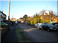
South eastern part of Greenhill Road, Kettering
Image: © Richard Vince
Taken: 18 Jan 2020
0.04 miles
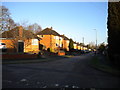
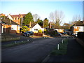
2
Western part of Greenhill Road, Kettering
Climbing towards Hall Lane.
Image: © Richard Vince
Taken: 18 Jan 2020
0.04 miles
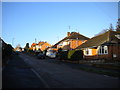
3
South end of Greenfield Avenue, Kettering
Seen from Greenhill Road.
Image: © Richard Vince
Taken: 18 Jan 2020
0.05 miles
4
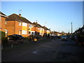
Eastern part of Greenhill Road, Kettering
Image: © Richard Vince
Taken: 18 Jan 2020
0.08 miles
5
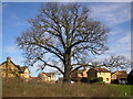
Oak Tree
The Ancient Oak Tree on Lake Avenue. The Developers were not allowed to remove this tree when the estate was built.
Image: © David Tucker
Taken: 13 Mar 2007
0.16 miles
6
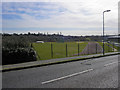
Kettering Athletics Club
The Athletics club taken from Thurston Drive.
Image: © David Tucker
Taken: 13 Mar 2007
0.18 miles
7
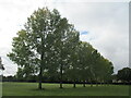
Line of trees by Lake Avenue, Kettering
Image: © Jonathan Thacker
Taken: 1 Oct 2020
0.18 miles
8
North end of Greenfield Avenue, Kettering
Image: © Richard Vince
Taken: 18 Jan 2020
0.19 miles
9
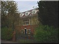
Bryn Hafod - Charles Wicksteed?s house
This house belonged to Charles Wicksteed benefactor to the town of Kettering. It was last used as an annex to a Nunnery and is now scheduled for re-development. Charles Wicksteed conceived and developed the famous Wicksteed Park of Kettering which is still very popular today and is held for the town through a charitable trust. Originally he was a steam ploughing contractor who came to Kettering and set up an engineering factory in Digby Street. After the Great War he branched out into the manufacture of metal playground equipment and became the largest maker in Europe. The equipment that most of us played on as youngsters would have been made by his company. The name of the house means Summer Dwelling Hill and acknowledges his younger days in Wales where his family lived at Upper Eyarth (nr Ruthin) and later at Hafod y Coed Farm (Tremeirchion) in the Vale of Clwyd, North Wales.
Image: © David M Jones
Taken: 16 Nov 2007
0.22 miles
10
Mead Road, Kettering
Taken from Lake Avenue
Image: © David Tucker
Taken: 13 Mar 2007
0.23 miles