IMAGES TAKEN NEAR TO
Windmill Avenue, KETTERING, NN15 7DB
Introduction
This page details the photographs taken nearby to Windmill Avenue, NN15 7DB by members of the Geograph project.
The Geograph project started in 2005 with the aim of publishing, organising and preserving representative images for every square kilometre of Great Britain, Ireland and the Isle of Man.

There are currently over 7.5m images from over14,400 individuals and you can help contribute to the project by visiting https://www.geograph.org.uk
Image Map
Images are licensed for reuse under creativecommons.org/licenses/by-sa/2.0
Notes
- Clicking on the map will re-center to the selected point.
- The higher the marker number, the further away the image location is from the centre of the postcode.
Image Listing (7 Images Found)
Images are licensed for reuse under creativecommons.org/licenses/by-sa/2.0
Image
Details
Distance
1
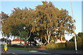
Silver birch trees on St Mary's Road, Kettering
Image: © David Howard
Taken: 13 Sep 2020
0.09 miles
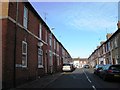
2
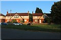
Houses on Elm Road, Kettering
From St Mary's Road
Image: © David Howard
Taken: 13 Sep 2020
0.10 miles
3
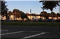
St Mary's Road, Kettering
Looking towards Elm Road
Image: © David Howard
Taken: 13 Sep 2020
0.12 miles
4
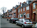
Housing on site of former shoe factory, St Peter's Ave Kettering.
This shows the site three years after the photo of the factory was taken. I had identified the factory as being one of Loake's, but I now think it was one of Griggs'. Can anyone provide information?
Note also the effects of a cold spring in 2006 on the tree: this photo was taken mid-April; the older one near the end of April.
Image: © John Stolarski
Taken: 12 Apr 2006
0.14 miles
5
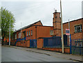
Shoe factory, Kettering
Factory on St Peter's Avenue, closed 2002. Now demolished and replaced by high-density housing. (See this on another photo.) Kettering is dotted with former shoe factories and leather works which have closed and been demolished for, or converted to, housing.
Image: © John Stolarski
Taken: 28 Apr 2003
0.14 miles
7
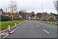
A6900 St Marys Road or St Mary's Road, Kettering
Temporary looking segregation of the cycle lanes over this stretch. The road name plates at each end differ in the use of an apostrophe.
Image: © Robin Webster
Taken: 5 Dec 2021
0.24 miles