IMAGES TAKEN NEAR TO
Arden Close, KETTERING, NN15 6UY
Introduction
This page details the photographs taken nearby to Arden Close, NN15 6UY by members of the Geograph project.
The Geograph project started in 2005 with the aim of publishing, organising and preserving representative images for every square kilometre of Great Britain, Ireland and the Isle of Man.

There are currently over 7.5m images from over14,400 individuals and you can help contribute to the project by visiting https://www.geograph.org.uk
Image Map
Images are licensed for reuse under creativecommons.org/licenses/by-sa/2.0
Notes
- Clicking on the map will re-center to the selected point.
- The higher the marker number, the further away the image location is from the centre of the postcode.
Image Listing (2 Images Found)
Images are licensed for reuse under creativecommons.org/licenses/by-sa/2.0
Image
Details
Distance
1
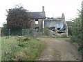
Dale's Lodge has seen better days
Derelict farm and house that appears to be destined for housing as the field all around has invertebrate fencing on its perimeter. So it's subject to a newt survey before works can begin.
Image: © Michael Trolove
Taken: 20 Oct 2011
0.14 miles
2
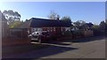
Grosvenor Road
A 1950s bungalow in Barton Seagrave.
Image: © Burgess Von Thunen
Taken: 19 Oct 2018
0.24 miles