IMAGES TAKEN NEAR TO
Barton Road, KETTERING, NN15 6RT
Introduction
This page details the photographs taken nearby to Barton Road, NN15 6RT by members of the Geograph project.
The Geograph project started in 2005 with the aim of publishing, organising and preserving representative images for every square kilometre of Great Britain, Ireland and the Isle of Man.

There are currently over 7.5m images from over14,400 individuals and you can help contribute to the project by visiting https://www.geograph.org.uk
Image Map
Images are licensed for reuse under creativecommons.org/licenses/by-sa/2.0
Notes
- Clicking on the map will re-center to the selected point.
- The higher the marker number, the further away the image location is from the centre of the postcode.
Image Listing (10 Images Found)
Images are licensed for reuse under creativecommons.org/licenses/by-sa/2.0
Image
Details
Distance
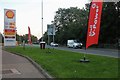
3
Barton Road, Barton Seagrave
By the petrol station
Image: © David Howard
Taken: 13 Sep 2020
0.06 miles
5
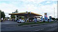
Service station on Barton Road (A6003)
Petrol 159.9p.
Diesel 181.9p.
Image: © JThomas
Taken: 23 Sep 2022
0.08 miles
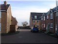
6
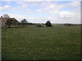
House and Field
This house is not set in hundreds of acres of fields but it is one house on a new development on the edge of Barton Seagrove.
Image: © Michael Patterson
Taken: 30 Mar 2006
0.16 miles