IMAGES TAKEN NEAR TO
Thurston Drive, KETTERING, NN15 6PB
Introduction
This page details the photographs taken nearby to Thurston Drive, NN15 6PB by members of the Geograph project.
The Geograph project started in 2005 with the aim of publishing, organising and preserving representative images for every square kilometre of Great Britain, Ireland and the Isle of Man.

There are currently over 7.5m images from over14,400 individuals and you can help contribute to the project by visiting https://www.geograph.org.uk
Image Map
Images are licensed for reuse under creativecommons.org/licenses/by-sa/2.0
Notes
- Clicking on the map will re-center to the selected point.
- The higher the marker number, the further away the image location is from the centre of the postcode.
Image Listing (8 Images Found)
Images are licensed for reuse under creativecommons.org/licenses/by-sa/2.0
Image
Details
Distance
1
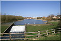
The Lake in front of Kettering Leisure Village
A View from the headlands showing the weir and lake in front of Kettering Leisure Village.
Image: © David Tucker
Taken: 9 Mar 2007
0.07 miles
2
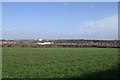
A view looking across Kettering from Broughton Grange.
Looking towards Kettering General hospital across the fields from Broughton Grange.
Image: © David Tucker
Taken: 9 Mar 2007
0.08 miles
5
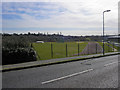
Kettering Athletics Club
The Athletics club taken from Thurston Drive.
Image: © David Tucker
Taken: 13 Mar 2007
0.14 miles
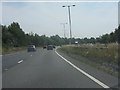
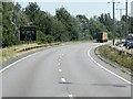
7
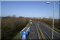
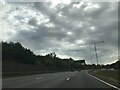
The A14 from Headlands Bridge
The busy A14 taken from the road bridge that goes to the Golf Club and Broughton Grange.
Image: © David Tucker
Taken: 9 Mar 2007
0.16 miles