IMAGES TAKEN NEAR TO
Edward Close, KETTERING, NN15 6HA
Introduction
This page details the photographs taken nearby to Edward Close, NN15 6HA by members of the Geograph project.
The Geograph project started in 2005 with the aim of publishing, organising and preserving representative images for every square kilometre of Great Britain, Ireland and the Isle of Man.

There are currently over 7.5m images from over14,400 individuals and you can help contribute to the project by visiting https://www.geograph.org.uk
Image Map
Images are licensed for reuse under creativecommons.org/licenses/by-sa/2.0
Notes
- Clicking on the map will re-center to the selected point.
- The higher the marker number, the further away the image location is from the centre of the postcode.
Image Listing (6 Images Found)
Images are licensed for reuse under creativecommons.org/licenses/by-sa/2.0
Image
Details
Distance
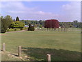
2
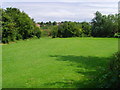
Playing Fields
I took this photo in summer 2007. It no longer looks like this: the hedge has gone and a new multi ball court has been built.
Image: © Sam Taiani
Taken: 20 Aug 2007
0.17 miles
5
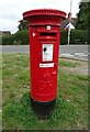
George V postbox on Pytchley Road
Postbox No. NN15 111.
Image: © JThomas
Taken: 21 Sep 2022
0.22 miles
6
Wicksteed Park
Looking down over the parkland towards the lakes which are in the distance in front of the trees.
Image: © Dot Potter
Taken: 5 May 2007
0.25 miles