IMAGES TAKEN NEAR TO
Hanover Close, KETTERING, NN15 6GH
Introduction
This page details the photographs taken nearby to Hanover Close, NN15 6GH by members of the Geograph project.
The Geograph project started in 2005 with the aim of publishing, organising and preserving representative images for every square kilometre of Great Britain, Ireland and the Isle of Man.

There are currently over 7.5m images from over14,400 individuals and you can help contribute to the project by visiting https://www.geograph.org.uk
Image Map
Images are licensed for reuse under creativecommons.org/licenses/by-sa/2.0
Notes
- Clicking on the map will re-center to the selected point.
- The higher the marker number, the further away the image location is from the centre of the postcode.
Image Listing (4 Images Found)
Images are licensed for reuse under creativecommons.org/licenses/by-sa/2.0
Image
Details
Distance
4
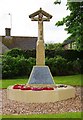
War Memorial, St. Botolph's Road, Barton Seagrave, near Kettering, Northants
Located on the Village Green next to St. Botolph's Church. Originally erected to commemorate those who died in the First World War, later the names of those who died in the Second World War were added.
A single-stepped octagonal base is surmounted by a flat topped pyramid styled square plinth with a short square sectioned column and a gabled figure of Christ on a cross. Inscriptions are on sides of plinth. A gravelled area surrounds the entire memorial. The memorial is Grade II listed.
Information from the War Memorials Register © WMR-38141.
Image: © P L Chadwick
Taken: 8 Jun 2019
0.25 miles