IMAGES TAKEN NEAR TO
Hanwood Park Avenue, NN15 6FS
Introduction
This page details the photographs taken nearby to Hanwood Park Avenue, NN15 6FS by members of the Geograph project.
The Geograph project started in 2005 with the aim of publishing, organising and preserving representative images for every square kilometre of Great Britain, Ireland and the Isle of Man.

There are currently over 7.5m images from over14,400 individuals and you can help contribute to the project by visiting https://www.geograph.org.uk
Image Map
Images are licensed for reuse under creativecommons.org/licenses/by-sa/2.0
Notes
- Clicking on the map will re-center to the selected point.
- The higher the marker number, the further away the image location is from the centre of the postcode.
Image Listing (10 Images Found)
Images are licensed for reuse under creativecommons.org/licenses/by-sa/2.0
Image
Details
Distance
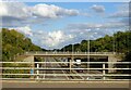
4

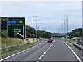
A14 - roundabout bridges, A6003/A6 junction
Image: © Peter Whatley
Taken: 27 Jul 2013
0.19 miles

8
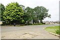
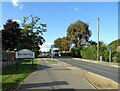
Barton Seagrave-Cranford Road
Close to a new housing development.
Image: © Ian Rob
Taken: 8 Jul 2021
0.24 miles
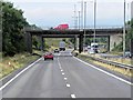
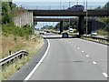
9

A14 eastbound at the southbound A6 junction
At this point the A6 resumes as an independent route number, having been subsumed as part of the A14 since Rothwell.
Image: © Peter Whatley
Taken: 27 Jul 2013
0.24 miles