IMAGES TAKEN NEAR TO
St. Michaels Road, KETTERING, NN15 6AU
Introduction
This page details the photographs taken nearby to St. Michaels Road, NN15 6AU by members of the Geograph project.
The Geograph project started in 2005 with the aim of publishing, organising and preserving representative images for every square kilometre of Great Britain, Ireland and the Isle of Man.

There are currently over 7.5m images from over14,400 individuals and you can help contribute to the project by visiting https://www.geograph.org.uk
Image Map
Images are licensed for reuse under creativecommons.org/licenses/by-sa/2.0
Notes
- Clicking on the map will re-center to the selected point.
- The higher the marker number, the further away the image location is from the centre of the postcode.
Image Listing (13 Images Found)
Images are licensed for reuse under creativecommons.org/licenses/by-sa/2.0
Image
Details
Distance
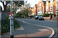
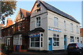
4
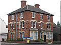
Kettering - house at junction of Broadway and Headlands
Home of the local radio station, Connect FM.
Image: © Dave Bevis
Taken: 6 Apr 2012
0.19 miles
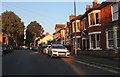
8
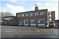
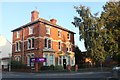
Kettering fire station
Kettering fire station, Headlands, Kettering, Northamptonshire
Image: © Kevin Hale
Taken: 5 Dec 2007
0.20 miles
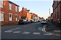
9
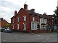
Ocean fish and chips on Broadway, Kettering
Image: © David Howard
Taken: 13 Sep 2020
0.21 miles