IMAGES TAKEN NEAR TO
Eider Close, KETTERING, NN15 5TH
Introduction
This page details the photographs taken nearby to Eider Close, NN15 5TH by members of the Geograph project.
The Geograph project started in 2005 with the aim of publishing, organising and preserving representative images for every square kilometre of Great Britain, Ireland and the Isle of Man.

There are currently over 7.5m images from over14,400 individuals and you can help contribute to the project by visiting https://www.geograph.org.uk
Image Map
Images are licensed for reuse under creativecommons.org/licenses/by-sa/2.0
Notes
- Clicking on the map will re-center to the selected point.
- The higher the marker number, the further away the image location is from the centre of the postcode.
Image Listing (8 Images Found)
Images are licensed for reuse under creativecommons.org/licenses/by-sa/2.0
Image
Details
Distance
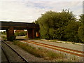
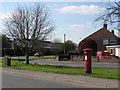
1
Burton Latimer - Crossroads on Station Road
Bridle Road to the left; Powell Road on the right.
Image: © Peter Whatley
Taken: 21 Apr 2010
0.14 miles
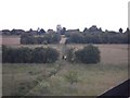
2
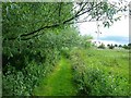
Winding trees
Path from a different direction
Image: © bethany ascott
Taken: 18 Jun 2011
0.15 miles
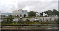
3
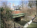
Weir and Weetabix
The River Isle passes by the huge Weetabix factory. As it does it drops down this weir.
Image: © Michael Patterson
Taken: 30 Mar 2006
0.16 miles
4
Burton Latimer - Postbox on Station Road
Image: © Peter Whatley
Taken: 21 Apr 2010
0.17 miles
5
From the train bridge
A picture taken from the train bridge
Image: © bethany ascott
Taken: 18 Jun 2011
0.22 miles
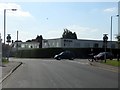
7
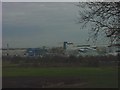
Had your Weetabix today?
The Weetabix factory at Burton Latimer nr. Kettering
Image: © David M Jones
Taken: 16 Nov 2007
0.23 miles