IMAGES TAKEN NEAR TO
Churchill Way, KETTERING, NN15 5RS
Introduction
This page details the photographs taken nearby to Churchill Way, NN15 5RS by members of the Geograph project.
The Geograph project started in 2005 with the aim of publishing, organising and preserving representative images for every square kilometre of Great Britain, Ireland and the Isle of Man.

There are currently over 7.5m images from over14,400 individuals and you can help contribute to the project by visiting https://www.geograph.org.uk
Image Map
Images are licensed for reuse under creativecommons.org/licenses/by-sa/2.0
Notes
- Clicking on the map will re-center to the selected point.
- The higher the marker number, the further away the image location is from the centre of the postcode.
Image Listing (7 Images Found)
Images are licensed for reuse under creativecommons.org/licenses/by-sa/2.0
Image
Details
Distance
1
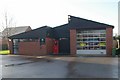
Burton Latimer fire station
Burton Latimer fire station, Piggotts Lane, Burton Latimer, Northamptonshire
Image: © Kevin Hale
Taken: 5 Dec 2007
0.17 miles
2
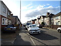
Burton Latimer, Churchill Way
Modern housing estate.
Image: © David Dixon
Taken: 16 Sep 2017
0.17 miles
3

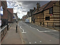
Sainsbury's, High Street, Burton Latimer
Image: © Alex McGregor
Taken: 3 Sep 2013
0.18 miles
4
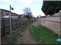
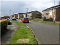
Urban Bridleway
This bridleway has become surrounded by housing on either side.
Image: © Michael Patterson
Taken: 30 Mar 2006
0.19 miles
5
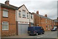
Burton Latimer old fire station
Burton Latimer old fire station, 4 Duke Street, Burton Latimer, Northamptonshire, was in use from 1901 to 1973
Image: © Kevin Hale
Taken: 6 Jun 2010
0.22 miles