IMAGES TAKEN NEAR TO
The Rushes, KETTERING, NN15 5PT
Introduction
This page details the photographs taken nearby to The Rushes, NN15 5PT by members of the Geograph project.
The Geograph project started in 2005 with the aim of publishing, organising and preserving representative images for every square kilometre of Great Britain, Ireland and the Isle of Man.

There are currently over 7.5m images from over14,400 individuals and you can help contribute to the project by visiting https://www.geograph.org.uk
Image Map
Images are licensed for reuse under creativecommons.org/licenses/by-sa/2.0
Notes
- Clicking on the map will re-center to the selected point.
- The higher the marker number, the further away the image location is from the centre of the postcode.
Image Listing (4 Images Found)
Images are licensed for reuse under creativecommons.org/licenses/by-sa/2.0
Image
Details
Distance
1
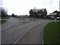
Raised Island
This new island to a new housing development is raised from the road surface. I assume this is to stop people taking shortcuts over the top.
Image: © Michael Patterson
Taken: 30 Mar 2006
0.09 miles
2
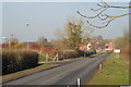
View towards Burton Latimer
Taken from the cab of my truck, looking along the Finedon Road towards Burton Latimer. The entrance to the industrial unit seen in my previous upload is on the left.
Image: © John Winder
Taken: 23 Jan 2015
0.11 miles
3
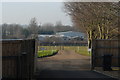
View from Barnfield Farm
Taken from my truck cab while sitting in the driver's seat looking through the open window! The location is deceptively rural:when I arrived, the narrow country lanes were busy with articulated lorries waiting to get into Burton Latimer industrial estate, causing distress to the indignant driver of one vehicle who was gesticulating rudely at one of the drivers as he drove past. When I left, all the traffic had gone.
Image: © John Winder
Taken: 23 Jan 2015
0.17 miles
4
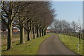
Driveway to Barnfield Farm
Snapped as I left after delivering a load of roof trusses for a barn conversion.
Image: © John Winder
Taken: 23 Jan 2015
0.24 miles