IMAGES TAKEN NEAR TO
Polwell Lane, KETTERING, NN15 5PS
Introduction
This page details the photographs taken nearby to Polwell Lane, NN15 5PS by members of the Geograph project.
The Geograph project started in 2005 with the aim of publishing, organising and preserving representative images for every square kilometre of Great Britain, Ireland and the Isle of Man.

There are currently over 7.5m images from over14,400 individuals and you can help contribute to the project by visiting https://www.geograph.org.uk
Image Map
Images are licensed for reuse under creativecommons.org/licenses/by-sa/2.0
Notes
- Clicking on the map will re-center to the selected point.
- The higher the marker number, the further away the image location is from the centre of the postcode.
Image Listing (3 Images Found)
Images are licensed for reuse under creativecommons.org/licenses/by-sa/2.0
Image
Details
Distance
1
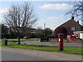
Burton Latimer - Postbox on Station Road
Image: © Peter Whatley
Taken: 21 Apr 2010
0.08 miles
2
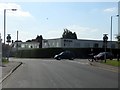
Burton Latimer - Crossroads on Station Road
Bridle Road to the left; Powell Road on the right.
Image: © Peter Whatley
Taken: 21 Apr 2010
0.12 miles
3
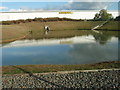
Sir Ken Morrisons duck pond
A balancing pond to collect run off water from Morrisons distribution centre at Latimer Park.
Image: © Michael Trolove
Taken: 20 Oct 2011
0.16 miles